
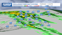
Our unsettled weather pattern has arrived. After a foggy morning with drizzle, more showers have moved in across New England along a warm front. While we will see some drying weather Thursday afternoon, spotty showers, drizzle and low clouds will keep our highs in the 50s.
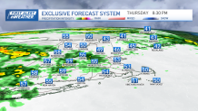
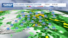
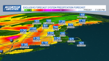
A larger wave of rain plus wind heads in Thursday night into Friday morning, and this is our First Alert timeframe. A couple of thunderstorms are also expected to be embedded within the steady rainfall. Don’t be surprised if you wake up to thunder, wind and heavy rain overnight.
We don’t expect widespread severe thunderstorms here, but some of the higher wind gusts may reach the surface from aloft thanks to the height of the thunderstorms. There may be some pockets of outages or damage at the coasts, Cape or islands through noontime Friday.
Get Boston local news, weather forecasts, lifestyle and entertainment stories to your inbox. Sign up for NBC Boston’s newsletters.
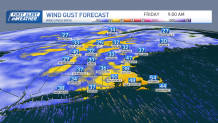
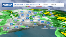
Wind advisory in effect for Massachusetts coast
Wind gusts from the south will be 40-50 mph, primarily Friday morning, and a wind advisory is up for the coast of Massachusetts from 2 a.m. to 2 p.m. Friday.
Some clearing may return for Friday afternoon. Then a couple pop up storms or showers develop prior to sunset -- especially a couple of thunderstorms in the mountains northwest.
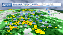
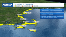
Coastal flooding possible Friday
Local
In-depth news coverage of the Greater Boston Area.


Coastal flooding will affect us again overnight Thursday around that 2 a.m. Friday high tide. Pockets of minor flooding in low-lying and typical spots will occur due to the astronomical high tides from the new moon this week. Plus, the South Coast Friday will see splashover and erosion due to the south wind, with waves 10-15 feet high between 7-11 a.m. Friday.
River flooding is likely in northern New England as we see snowmelt combined with the heavy rainfall Friday morning. Crests will approach minor flood stage by the weekend.
The weekend will be quieter. Saturday, there will be a brief shower and gusty west winds with highs in the 50s. Sunday will see increasing clouds, a late shower and temps around 60.
A wave of showers moves through for overnight Sunday, but it seems to get out in time for the runner for the Boston Marathon as they head to the start line in Hopkinton. There may be some humidity in the morning, then drying during the race after the sun comes up. Temps reach the 60s, which will be too warm for runners, but great for spectators. Breezes will be from the northwest with some sunshine as runners approach the finish line in Boston.
In our extended 10-day forecast, we have declared an end to winter, as our pattern continues to show warm temps and no hints of snow. Highs in the 50s and 60s continue into next week.
