Henri, which was downgraded from a hurricane to a tropical storm Sunday morning, was downgraded again to a tropical depression about eight hours after making landfall in New England.
The National Hurricane Center said Henri came ashore in the Rhode Island coastal town of Westerly around 12:30 p.m. It had earlier passed over Block Island, a small but popular tourist island 13 miles offshore in Block Island Sound. Henri was packing maximum sustained winds of 60 miles per hour and it was producing 19-foot waves in some places just before making landfall.
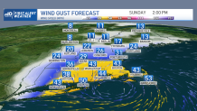
An area of 60 to 75 mph wind gusts verified around Narragansett Bay, and eastern Massachusetts saw occasional gusts of 40 to 60 mph. But this was limited to squalls. The wind has been mostly east and not southeast, which is helping to limit damage.
Get Boston local news, weather forecasts, lifestyle and entertainment stories to your inbox. Sign up for NBC Boston’s newsletters.
The National Hurricane Center's 8 p.m. update said Henri had weakened to a tropical depression but is still expected to produce heavy rainfall and flooding across portions of New England through Monday.
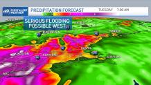
Away from the coast, rainfall was the biggest story Sunday. Torrential downpours were likely near the center of, and to the west of, Henri’s track.
Flood watches were in effect for much of central and western New England, where some were expected to see more than four inches of rain.
Somewhere, likely west of the Connecticut River toward the New York border, we may even see amounts approaching eight inches.
As Henri came ashore, it weakened fairly quickly in the wind aspect, but rain was a different story. While across eastern Massachusetts into Southeastern New Hampshire and much of Maine rain is not that big a factor Sunday, the rain may return with scattered showers and downpours Sunday night and Monday as the center of circulation may not be out of New England actually until later Tuesday.
More on Henri


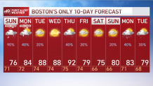
More breaks of sunshine are likely Monday, with temperatures in the low 80s.
Then finally when we have a mostly rain free day in much of New England Tuesday and then into Wednesday, high temperatures are going to be close to 90 degrees. The next weather front is expected later Thursday and Friday with a round of heavy thunderstorms possible, and temperatures cooling towards the end of the week. Hopefully staying nice and dry into the weekend, as seen in our First Alert 10-day forecast.