
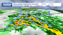
More rain and wind is on the way, as we find ourselves on the doorstep of yet another strong frontal system ready to take aim at our region.
We remained on the cloudy side Thursday afternoon through Thursday evening with scattered showers and patchy fog. The bulk of the action is moving in Thursday night.
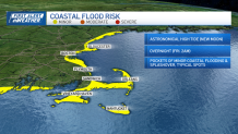
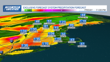
If there is any good to take from it, much of the rain and wind will be short lived, exiting by the early afternoon Friday, with some improvement in conditions. Unfortunately, the rain falls in a short period of time, upwards of an inch to an inch and a half in some spots, which will likely produce some localized flooding.
Get Boston local news, weather forecasts, lifestyle and entertainment stories to your inbox. Sign up for NBC Boston’s newsletters.
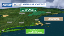
So far this year in Boston, we have received 18.83 inches of rain/melted snow -- that’s 6.67 inches above the norm, and we’ll likely add another inch or so to it in the next 12-24 hours! Where we still have snowpack across northern New England, flooding is expected as the heavy rain moves in, swelling some streams and rivers.
What’s good about all of the rain is the fact that at this time of year, we tend to have a lot of underbrush leftover from the previous year, which dries out before the new springtime growing season gets going, and unfortunately allows for brush fires to crop up. Right now, we’re not seeing that.
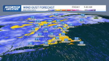
Overall winds will gust up to or just over 30 mph late Thursday night into Friday morning, but along the coast, in particular south coastal New England and the mid-coast to Downeast Maine, southerly winds will crank up to 50 mph, likely causing some minor damage and isolated power outages.
We’ll see improvements through the course of Friday afternoon from south to north, with a few lingering showers around and diminishing winds.
The weekend looks much drier, but we’ll remain a bit unsettled and breezy Saturday, with the slight risk for a pop up shower and snow showers across the mountains of northern New England.
Local
In-depth news coverage of the Greater Boston Area.


Another weak system may bring some rain showers late Sunday into the early portions of Sunday night. Overall temperatures will be in the 50s, and cooler across the North Country. As we take a look into next week, temperatures will really start to feel more like spring, with highs well into the 60s!
Marathon Monday looks fantastic, with highs in the 60s and a light west wind. We’ll have to watch for an afternoon sea breeze along the coast as the runners make their way into Boston.
