
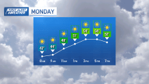
A sunny start to the week with seasonable afternoons all week. Monday and Tuesday are looking bright, a reinforcing shot of cool air sweeping in from the north will make for some chilly mornings.
Highs in the mid to upper 50s, lows in the mid to upper 30s. That cold air is the culprit to a lingering frost potential this week. Protect any sensitive plants, especially for areas not right at the coast. Cover or bring plants indoors if that's an option.
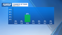
Changes coming into Wednesday, a weather system moving in from the Midwest will bring clouds and light rain, and rain totals will likely stay below 0.5" — just enough to make for a dreary midweek.
Get Boston local news, weather forecasts, lifestyle and entertainment stories to your inbox. Sign up for NBC Boston’s newsletters.
Wednesday night into Thursday, a cold front passes, leading to gusty northwest winds and cooler air. Wind gusts could exceed 30 miles per hour, and temperatures by Thursday morning might dip below freezing for southern New Hampshire and central Massachusetts.
The day will recover to the mid-50s under clear skies. From Friday through the weekend, high pressure will stabilize the weather, leading to dry conditions and seasonal temperatures in the upper 50s to low 60s during the day and mid-30s to low 40s at night.
