
Plenty of mild temperatures in the past two days but for the next couple, we step back a bit. Clouds will get the upper hand Wednesday as we hold off showers until late day and evening.
Breezes stir out of the southeast for a change, keeping coastal communities in the mid-50s. Farther inland, away from the chilly Atlantic waters, we could still hit 60 in spots west of Interstate 128 and especially along I-495.
The showers could sprinkle the game at Fenway this evening, but it doesn't look like a washout. We'll be hard-pressed to even get a rain delay out of them. Most will scoot out after midnight anyway.
Get Boston local news, weather forecasts, lifestyle and entertainment stories to your inbox. Sign up for NBC Boston’s newsletters.
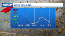
Winds increase Thursday and a few showers pass through from time to time. Heavier rain and downpours will sweep in from the west later at night and carry into Friday morning.

High winds are expected (again) as the storm strengthens. Gusts could top 45 to 50 mph from Cape Ann to Cape Cod and the Islands. We'll see the winds ease a bit Friday afternoon as the storm begins to pull away.
The weekend seems OK, but it'll still be gusty, cool and a passing sprinkle on Saturday. Sunday is the pick as we mosey into 60-degree territory by afternoon.

Right now, the Boston Marathon appears warm. A westerly (tail) wind will push you up Heartbreak Hill, but it also keeps the sea breeze away from downtown. Highs could reach 70 after a start in the low 50s.
