
With the eclipse behind us, the focus returns to the spring warmth. Or at least in the next two days, the diminishing warmth. Monday's highs in the 60s now are shoved west, away from the coast.
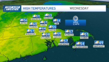
Sea breezes will turn to south/southeast winds by Wednesday, knocking us back a few more degrees. This is by no means a sharp cooldown, but it certainly isn't returning to the status quo of Monday's upper 60s.
We're also eying a sizeable storm later in the week (sizable also doubles as strong in this case). A couple of days ago, this seemed like a run-of-the-mill spring storm. But the latest guidance has upped the ante for heavy rain and strong winds…again.
Get Boston local news, weather forecasts, lifestyle and entertainment stories to your inbox. Sign up for NBC Boston’s newsletters.
While our temperatures level off, the showers come in. A few lightweight sprinkles are in order by midweek, then some more hefty rain on Thursday along with an increasing wind.
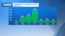
The event culminates on Friday with early downpours and gusts from 40 to 50 miles per hour (par for the course in this unbelievable pattern). Some isolated outages are possible.

Colder air will shift in for the start of the weekend. At this point, it appears short-lived as we move back near 60 for Sunday and in the 60s for Marathon Monday. Not ideal running weather, but with an expected tailwind, all is not lost.
