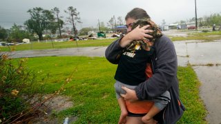
- An unforgiving hurricane season shattered records this year, producing the most named storms ever seen in the Atlantic and battering parts of Central America and the U.S. Gulf Coast.
- The Atlantic season officially runs from June 1 to Nov. 30. But this year, storms formed weeks before the season began and stretched through November, when hurricane activity typically winds down.
- Scientists warn of even worse hurricane seasons as climate change triggers more frequent and catastrophic storms.
An unforgiving hurricane season shattered records this year, producing the most named storms ever seen in the Atlantic and battering parts of Central America and the U.S. Gulf Coast.
The Atlantic season officially runs from June 1 to Nov. 30. But this year, storms formed several weeks before the start of June and stretched on through November, when hurricane activity usually winds down. And there's no clear end date as forecasters track possible developments in December.
But one thing is clear: No previous hurricane season in recorded history has had so many storms. The 2020 season saw 30 named storms, 13 of which were hurricanes. An average season has 12 named storms and six hurricanes, according to the National Oceanic and Atmospheric Administration.
Scientists initially predicted an extremely active season due to hotter-than-average temperatures in the tropical Atlantic Ocean and Caribbean Sea and an enhanced West African monsoon. NOAA, in one of its most active outlooks ever, predicted in August that this year would see up to 25 named storms, with up to 11 developing into hurricanes.
The 2020 season topped even those expectations and surpassed the second-highest number on record of 28 storms in 2005, the year Hurricane Katrina hit the Gulf Coast.
As the season comes to an end, scientists warn of even worse hurricane seasons as climate change triggers more frequent and catastrophic storms.
Money Report
Areas that were hit the hardest
The World Meteorological Organization ran out of hurricane names in the alphabet in September, when Tropical Storm Wilfred developed in the eastern Atlantic Ocean. Meteorologists resorted to using Greek letters, which they've only done once before, in 2005.
Six of the hurricanes this year were major storms, meaning they were Category 3 or higher and had winds of 110 miles per hour or higher.
The strongest hurricane was Hurricane Iota, which struck Central America and Colombia as the latest known Atlantic hurricane to become a Category 5. Iota devastated areas already recovering from Hurricane Eta just two weeks earlier. It killed more than 50 people in Guatemala and left thousands displaced in Central America.
The U.S. Gulf Coast was also battered this year. A record five storms made landfall in Louisiana, where displaced residents struggling to rebuild were hit with one storm after another. Hurricane Laura in September, one of the strongest storms ever to hit the state, was followed just six weeks later by Hurricane Delta.
More from CNBC Environment:
'I lost everything': In hurricane-ravaged Louisiana, people struggle to rebuild
Biden will rejoin the Paris Climate Accord. Here's what happens next
Gerry Bell, NOAA's lead hurricane forecaster, said that 18 of 26 hurricane seasons have been above normal and 10 have been extremely active since 1995. With this trend, Bell emphasized the importance of hurricane preparedness.
"Many millions of people along both the Gulf Coast and the Atlantic Coast were impacted by these storms," Bell said. "There is no question that hurricane planning and preparedness were key in helping to minimize loss of life and hardship."
How climate change has played a role
This year's season has fueled questions on how climate change is impacting hurricanes in the Atlantic.
Research shows that climate change is making hurricanes stronger and more destructive and increasing the likelihood of more frequent major hurricanes.
Models indicate that global warming increases the chance of storms rapidly intensifying as tropical oceans heat up. Storms that undergo rapid intensification, defined as a 35 mph increase in wind speeds over 24 hours, are hard to predict and leave a short amount of time for people to evacuate.
"[Rapid intensification] is something we saw several times this year," said Michael Mann, director of Penn State's Earth System Science Center. "This phenomenon appears to be tied, once again, to unusually warm ocean water."
For instance, Hurricane Laura in August was the fastest-intensifying hurricane ever in the Gulf of Mexico. The storm decimated entire homes, killed more than a dozen people in Louisiana and caused estimated damage of up to $12 billion.
The speed of tropical storms making landfall has also slowed during the last few decades, causing worse rainfall and flooding. Warming in the Arctic has weakened atmospheric circulation, likely slowing hurricane development by causing a slowing of the jet stream.
This hurricane season had record water levels in areas including the Gulf Coast, where the slow-moving Hurricane Sally stalled over the Gulf of Mexico in September and brought record water levels since Katrina in 2005, according to NOAA's National Ocean Service stations.
"The impacts of climate change are no longer subtle. We're seeing them play out right now in the form of unprecedented wildfires out West and an unprecedented hurricane season back East," Mann said.
"Things will only get worse if we continue to burn fossil fuels and generate carbon pollution," he added. "This current hurricane season lays bare the reasons we must act on climate now."


