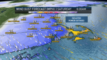
The wind and the rain will continue to pick up tonight as conditions deteriorate. Overnight through 10 a.m. Saturday is when the worst of the rain and wind will take hold.
A tropical storm warning is in effect for parts of Downeast Maine, all of Cape Cod, Nantucket and Martha’s Vineyard.
Rain:
Showers have already been moving in from the south as Dorian’s outer bands spread northward. Isolated thunderstorms may be found within the tropical downpours. The rain continues all night, into Saturday morning, then will end abruptly from west to east late morning.
Cape Cod will see about 1-3 inches of rainfall with isolated spots receiving 4 inches or more. North and west, the rainfall amounts will be well below 1 inch.

Wind:
The northeast wind will be cranking after 11 p.m. and will continue through dawn with gusts from the northeast 40-60 mph across the Cape and islands. Pockets of damage and power outages will be possible. The wind will also stay strong along the south shore and across Cape Ann. The wind will switch to a northwesterly direction as the storm pulls away Saturday afternoon. There may be a couple wind gusts up to 40 mph across interior Massachusetts on the backside.
Waves:
Wave heights continue to increase tonight with the peak waves Saturday morning as the center of Dorian passes about 120 miles southeast of Nantucket. At the center of the storm, wave heights will be 30-40 feet. At our coastline, the waves will be 10-20 feet with a northeast wind Saturday morning.
There’s an offshore wind by Saturday afternoon as the waves continue to churn. We're not expecting widespread coastal flooding, but Nantucket Harbor and the bay side of Cape Cod may see some splashover or minor pockets of flooding. Tides are astronomically low and this storm is moving pretty quickly.
Local
In-depth news coverage of the Greater Boston Area.
Ferries:
All Steamship Authority ferry service to and from Nantucket was canceled for Friday night starting at 4:30 p.m. The terminal in Oak Bluffs is closed Friday and likely through at least Saturday, with all trips diverted to Vineyard Haven.
All of the service's MV Iyanough trips for Saturday were canceled, with more service to Nantucket and Martha's Vineyard likely to be canceled Saturday.
Steamship is waiving change and cancellation fees due to the storm, and is encouraging people with trips scheduled for Saturday and Sunday to make alternate arrangements if they have flexible travel plans.
More details here: steamshipauthority.com
Hy-Line Cruises also said it was canceling all inter-island service between Martha's Vineyard and Nantucket Saturday.
Rest of the Weekend:
Saturday afternoon will be breezy but we clear out. Sunday looks mostly sunny, with a couple showers across northern New England in the afternoon along a frontal boundary. Highs will be in the mid 60s Saturday, to the low 70s Sunday.
10-Day Outlook:
No major storms are in the forecast for next week. We have another chance for scattered rain on Wednesday into early Thursday. Next weekend will bring a chance for showers as well. Highs will remain very fall-like in the 60s to low 70s and overnight lows in the 40s to 50s.


