
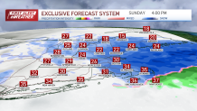
The National Weather Service said it was a “major winter storm” that would continue into Sunday evening, with up to a foot of snow in parts of New England.
Follow NBC10 Boston on…
Instagram: instagram.com/nbc10boston
TikTok: tiktok.com/@nbc10boston
Facebook: facebook.com/NBC10Boston
X: twitter.com/NBC10Boston
We’re seeing a wide range of snow totals, which were expected, from little or none along the immediate coast, to over a foot inland!
The storm system responsible for it will continue to intensify south of New England and pull away overnight. As it does so, we’ll see another burst of moderate to locally heavy snow fall through Sunday afternoon and into the evening before coming to end early Sunday night. Several inches more of snow is expected across portions of the area, which will make traveling a bit hazardous, especially on the untreated surfaces.
Stream NBC10 Boston news for free, 24/7, wherever you are.
Flash freeze possible later Sunday
Get updates on what's happening in Boston to your inbox with our News Headlines newsletter.
At the same time, cold air banked over northern and central New England will continue to flow back into southern areas through Sunday afternoon, which may result in a flash freeze, especially along the coastline and south of Boston. This is the point where some communities that had little snow could pick up a quick coating to an inch or so.
This afternoon will be a good time to clean up as much snow as you can before nightfall, especially in those areas that are still hovering around freezing, because we’re expecting overnight lows to drop into the teens and low 20s.
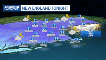
After a cold start with some leftover icy spots on untreated surfaces, Monday will feature a good amount of sunshine with temperatures reaching the mid 30s south, upper 20s to low 30s north as high pressure builds into the region.

First Alert issued for Tuesday-Wednesday storm
Local
In-depth news coverage of the Greater Boston and New England area.


It doesn’t stay quiet for long, as we find ourselves in the middle of a very active pattern and another major storm on our doorstep arriving late Tuesday and exiting Wednesday. This time around, much of southern New England will be on the warm side of it as this system takes an inland track, with some snow across the north before changing to rain.
This system promises to pack a big punch, with heavy rain, damaging winds, and coastal flooding, which has prompted our team to issue a First Alert for Tuesday night and Wednesday.
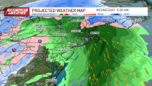
We’ll also have to keep an eye on some of the rivers and streams due to the expected heavy rain and potential snow melt. Once we’re done with Sunday’s storm, we’ll help you get focused and prepared for the next one.
Oh, by the way, yet another storm looks to bring more, snow, wind, and rain by the start of next weekend. But let's take one storm at a time for now!
Track the storms with our live weather radar
PHOTOS: Snow blankets Mass., NH, delighting many (but not drivers)


