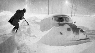
BOSTON – FEBRUARY 7: Falling and drifting snow surrounds a car on Morrissey Boulevard during the early morning hours of the blizzard of 1978. (Photo by John Blanding/The Boston Globe via Getty Images)
Forty five years later, the Northeast Blizzard of 1978 continues to live on in infamy as one of the most intense winter storms to ever strike New England, bringing with it hurricane-force winds and towering snowfall totals, which left the region paralyzed for over a week.
Stream NBC10 Boston news for free, 24/7, wherever you are.
From a meteorological standpoint, the blizzard began as a low pressure system off the coast of North Carolina on Feb.5, before heading up the coast and then passing slowly south of New England on the 6th and 7th of February.
Get updates on what's happening in Boston to your inbox with our News Headlines newsletter.
The storm brought with it significant impacts to southern New England, including over two feet of snow to both Boston and Providence, Rhode Island. The storm still ranks as Providence's greatest snowfall, and ranks second for Boston. Boston's record was beat by just a half inch of snow in 2003.
Along with the high snowfall, the blizzard brought with it high winds and created storm surges between 2.5 to 4.5 feet along the east coast of Massachusetts. There was major coastal flooding, resulting in the damage or destruction of nearly 11,000 homes, according to the National Weather Service.
"The Blizzard of 1978 really is the benchmark storm for Boston," NBC10 Boston Chief Meteorologist Matt Noyes said, despite there having been worse snowfall and coastal flooding since. "But the thing is, the way the Blizzard of '78 came in, it came in fast, it came in hard. It lasted for more than a day, and it came in while folks were on the road. And they ended up stranded on the road."

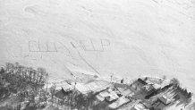
Pictures of the storm famously show cars buried in snow on Massachusetts interstates. First responders were going car to car, trying to help people and save lives.
Local
In-depth news coverage of the Greater Boston and New England area.
The National Weather Service says that despite the technological limitations of the 1970s, meteorologists were able to forecast the storm pretty accurately, but say that 45 years later, there would be much more warning of a similar storm
There's also more ways to get information out to the public nowadays, which would also improve response, the NWS said.
"You didn't have the same kind of detail that you do today, where you can get it down to the hour-by-hour forecast on how it was going to move in," Noyes said. "So really, technology didn't afford the same amount of detail, but on top of that, the technology really made it that even just getting whether there'd be a major storm or not was something not everyone could do."
Noyes said that with changing weather patterns, an intense storm like this has become more likely.
"We're seeing stronger storms," Noyes said. "For example, just southeast of us today, we have yet another storm with an eye-like feature... You look at Buffalo, and the fact they got there 2.5 feet of snow with their terrible subzero wind chill."
Noyes said a difference now is that areas tend to stay in a snowy pattern, or tend to stay away from the snow, as seen this season in northern versus southern New England.


