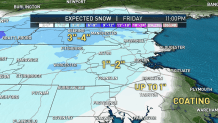
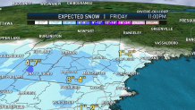
The remnants of two significant storms will cross New England in rapid succession over the next 30 hours, bringing rain, snow and a gusty wind.
The first system is the remnant of once-Hurricane Zeta, continuing to weaken as it heads across the Southeast and Mid-Atlantic, but spreading rain north into New England from Thursday morning to evening, slowing travel, including the evening commute.
Get top local stories in Boston delivered to you every morning. Sign up for NBC Boston's News Headlines newsletter.
Just as the remnants of Zeta depart east and out to sea, the strong energy that drove a southern United States snow and ice storm this week will approach New England, spreading rain farther north and prompting a storm center to develop just south of New England.
As the barometer falls at the storm center to our south, air will be drawn into the storm center, meaning a northerly wind takes hold of New England and that’s important: a north wind will carry cold air southward overnight Thursday night into Friday morning, taking a rain/snow line that starts in the higher terrain of the White and Green Mountains and carrying it first down in elevation, then southward, reaching the suburbs north and west of Boston on the Interstate 95 corridor by predawn Friday morning.

Before precipitation shuts down entirely Friday afternoon, the snow line should push through Boston and into some of the suburbs south of town, too, with a gusty north wind of 30 to 40 mph in eastern Massachusetts and Rhode Island, with 20 to 30 mph gusts farther inland making a few power outages possible in areas that pick up 3 to 4 inches or more of snow on trees that still cling to some late season leaves.

Friday afternoon should see temperatures above freezing for many in central and southern New England as the roads start to dry, but it won’t be comfortable – high temperatures are unlikely to reach much beyond 40 degrees, with some spots shy of that!
Local
In-depth news coverage of the Greater Boston Area.
The chilly air sets us up for sub-freezing temperatures across New England Friday night, including in our metropolitan areas, with the only exceptions on Cape Cod and perhaps some spots along the south coast of Connecticut.
Saturday will be bright but chilly with highs in the 40s, dropping to the 30s after dark for those trick-or-treating later in the evening.
Temperatures will be moderate Sunday but that incoming milder air creates increasing clouds and probably a few showers, particularly during the afternoon.
Thereafter, New England is set for the delivery of two shots of chilly air – one Monday that keeps temperature in the 40s and another Tuesday that will leave high temperatures struggling just to make 40 degrees on Election Day Tuesday!
While a snow shower isn’t impossible Monday night with the arrival of that new cold air, most of next week looks dry as a large dome of high pressure – fair weather – builds across the Northeast.


