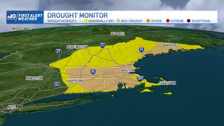
Our latest drought map was released Thursday and it shows the drought has gotten worse across the northeast.
Each week, the National Drought Mitigation Center at the University of Nebraska-Lincoln takes the rain data and soil moisture info through Tuesday on a given week. Then in turn they issue a drought map every Thursday.
WATCH ANYTIME FOR FREE
Stream NBC10 Boston news for free, 24/7, wherever you are. |
With lack of rain in New England in the last several days, it’s no surprise we see some significant changes. We went from about 25% of Massachusetts in moderate drought last week, to this week about 75% under this category. Almost all of the commonwealth has at least abnormally dry conditions. Boston has been in the “moderate drought” for a few weeks, while this week added Worcester, Springfield, Fitchburg, the Merrimack Valley, the Connecticut River Valley, and the Blackstone Valley.

Get updates on what's happening in Boston to your inbox. Sign up for our News Headlines newsletter.
Since January 1, Boston has had 5.59" of rain below normal, with only 15.84" of precipitation since 2022 began. This month in particular, we picked up 2.33" for June and that is 1.45" below average. It rained on June 1, 2, 3, 8 and 9, giving us 0.88” total. Then we had a little rain on June 13, then 0.31" on the 19, with the last decent rain on June 27 with 0.65".
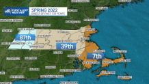
Eastern Massachusetts has had a very dry meteorological spring, which is March, April and May. The North Shore, South Shore, Cape, and Boston rank as 7th driest of the last 130 years of data on record. Worcester, Fitchburg, and Springfield rank as 39th driest, and far western Massachusetts ranks as 87th driest.
After a hot Friday, we have a chance for soaking rain across southern New England on Saturday, as well as a severe weather risk.
Local
In-depth news coverage of the Greater Boston Area.
Stay tuned for updates on rain potential and for the severe storm threat as we head into the holiday weekend.


