
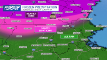
We’re getting one last blast of winter on Saturday night, with ice expected to cause some issues in parts of northern New England.
Follow NBC10 Boston:
https://instagram.com/nbc10boston
https://tiktok.com/@nbc10boston
https://facebook.com/NBC10Boston
https://twitter.com/NBC10Boston
https://bsky.app/profile/nbcboston.com
While it’s not washed out every minute of the weekend, it’s certainly not a stellar forecast. Showers will pester us through mid-morning Saturday, with mist, fog, and drizzle taking up in the afternoon. There will be pauses in the rain from time to time, but the bigger story will the falling temperatures and the possibility of ice in Greater Worcester Saturday night and early Sunday.

WATCH ANYTIME FOR FREE
Stream NBC10 Boston news for free, 24/7, wherever you are. |
Early high temperatures will be in the low and mid-40s before colder air moves in during the afternoon and drops us to the mid and upper 30s. It’s this steady drop that could allow some icing to seep into southern New Hampshire and the Worcester Hills later Saturday and Saturday night. Amounts will be light and spotty, but any thin glaze is bad news. Farther north, where the cold is more deeply entrenched towards Manchester, Derry, and Dover, New Hampshire, the icing will be more expansive, resulting in slick roads and possible power outages.
Get updates on what's happening in Boston to your inbox. Sign up for our News Headlines newsletter.

The story isn’t as bleak on Sunday, with more wet weather early, then another period of drier weather in the afternoon. The final leg of rain will come through on Monday, with possible downpours in the afternoon. The best news all weekend is that Monday will see the temperatures soar back to the low and mid-60s. All told, we’re in for a soaking, too. Guidance is suggesting a widespread inch of rain, with lesser amounts in southeast Massachusetts.

We’ll catch a break on Tuesday and Wednesday before another soggy system stumbles in by Thursday and Friday.
Stay dry and enjoy the weekend.
