A mild day with new records in the south for Boston and Worcester, where upper 50s and 60s made their statement.
Strong Winds Could Cause Power Outages
WATCH ANYTIME FOR FREE
>Stream NBC10 Boston news for free, 24/7, wherever you are. |
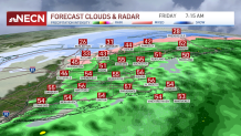
However, our focus now shifts to our First Alert overnight as our wind gusts will crank after 10 p.m., watching the highest wind gusts after midnight and lasting through 8 a.m. tomorrow. A 50-60 mph range will take over most of New England but the potential of the highest wind gusts remains in the south and southeast; stretching from eastern Connecticut into the Cape and the islands. Nantucket is forecasted to reach 70 mph and the Cape to exceed 60 mph.
Get updates on what's happening in Boston to your inbox. Sign up for our >News Headlines newsletter.
It will be windiest between 4 a.m. and 8 a.m. We might be watching scattered power outages for which we’ll have to start prepping our flashlights, charging up our electronics and keeping loose trash bins safe before they get blown by the wind.

Temperatures to Drop Friday Afternoon
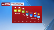
The winds should lose strength by early afternoon tomorrow into the evening hours, but as that happens we’ll also see a drop in temperatures. Yes, this is the tricky part; we’ll start the day with the highest temperatures being in the upper 50s and low 60s tomorrow morning and then we’ll drop into the 30s and 20s by 3 p.m. This will be courtesy of our cold front that will also help set up the stage for a cool and dry afternoon that will allow for our next low pressure to bring snow showers instead of in in the northern states on Saturday afternoon.

Saturday Showers Then a Dry Sunday
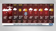
Our weekend will be split, with scattered and short-lasting snow on Saturday and a dry Sunday. As a high pressure system stalls south on Sunday, our highs will climb to the 50s by Monday, but more active and rainy days take over the 10-day forecast next week.


