What to Know
- Snow already moves into western New England by Saturday evening, starting to fall in Boston between 8 and 11 p.m.
- Parts of northern New England could see up to 2 feet of snow, while Greater Boston will likely see somewhere between 5 to 9 inches.
- Strong winds Sunday could lead to power outages, with brutal cold moving in following the storm on Monday.
A quick disturbance moves through during the Friday morning commute, bringing light snow and a wintry mix. A major winter storm Saturday night and Sunday will affect travel across the northeast.
Friday Light Snow:
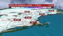
First to our quick system for Friday. This low pressure tracks through New England Friday morning during the height of the commute. As we all know, it just takes a coating sometime to create a traffic nightmare. A coating to 2 inches of snow (higher elevations) will be possible through late morning, with the light snow flipping to spotty rain southeast. Clearing sky in the afternoon and highs in the mid 30s to low 40s.

Saturday Night/Sunday Storm:
Saturday night into Sunday we will have a major winter storm across the northeast and a First Alert. Northern New England will see heavy snowfall, while southern New England could get snow to freezing rain, to rain, back to snow. It's a complex system that also brings damaging wind and coastal flood threats. Time to break it down.
Local
In-depth news coverage of the Greater Boston Area.
Timing:
Snow already moves into western New England by Saturday evening, starting to fall in Boston between 8 and 11 p.m. Heavy snow accumulates as fluffy consistency at first, changing to more pasty consistency as our temps slowly rise across southern New England overnight. Warmer air tries to move over the colder, dense air, and this may lead to freezing rain for a few hours Sunday morning from Boston to Hartford. Snow continues across Vermont, New Hampshire, and Maine. Flipping to rain across southern Connecticut, Rhode Island and Massachusetts between 5 and 8 a.m. Keep in mind the rain/snow line may move a touch farther north or south. Colder air moves in as the center of low pressure moves into the Gulf of Maine. With that north wind, colder air returns and we flip back to a mix then snow across Boston, Rhode Island and Connecticut. The rain/snow line collapses across the coastline toward the southeast Sunday afternoon. Snow continues to fall across most of New England. Snow tapers off Sunday afternoon and evening
Snow Totals:
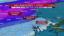
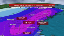
Southern Vermont, central New Hampshire, through central Maine will see 18 to 24 inches of snow, higher across the mountain peaks. There will be about 12 to 18 inches across southeastern New Hampshire and along the Maine coast. Expect a foot or more in northern Vermont and New Hampshire and around 5 to 9 inches of snow (with lots of ice mixing in) from Boston to southern Worcester County. We should see 9 to 18 inches from Worcester north to the New Hampshire boarder and west to the Berkshires, with more sleet and freezing rain mixing in from the Massachusetts Turnpike and then south. There will be sleet and freezing rain with a 3 to 6 inch range across Hartford to Providence through Plymouth, Massachusetts. The South Coast will get 1 to 3 inches and more of a mix to rain. It's mostly a rain event across Cape Cod and the islands. The flash freeze Sunday night may lead to everything icing up, even across the islands.


Ice:
Cold air will be in place with the onset of this storm system Saturday night. Warm air tries to wedge in from the south, and may move as far north as southern New Hampshire by Sunday morning. We may see a situation where Boston has snow, then freezing rain, and then turns back to snow. Freezing rain can lead to ice caking, and everything may amount to a quarter inch. Once you have that much ice, we will be dealing with widespread power outages and tree damage.
Wind:
East wind by dawn Sunday, gusting between 40 and 50 mph across the coast and Cape. Twenty to 40 mph inland gusts. Scattered power outages and near blizzard conditions likely north and west of Boston. Wind direction flips by afternoon, coming from the north, northwest, ushering in our flash freeze situation by Sunday evening for all of New England.
Coastal Flooding:
Minor to moderate coastal flooding for Sunday morning’s high tide. We have astronomically high tides due to the full moon on Monday. The higher of the two tides on Sunday will be in the morning. This coincides with an onshore wind and increasing wave heights of 8 to 15 feet offshore. This will create a surge of 1 to 3 feet. Minor to pockets of moderate beach erosion are likely too. Our wind changes direction, more offshore by the Sunday evening high tide as the storm pulls farther out to sea. Other than splashover across north facing beaches, the flood threat diminishes greatly for Sunday night.
10-Day Outlook:
Brutal cold by MLK Day Monday. We expect many to be without power from the weekend storm, and with highs only in the low teens, we have declared Monday a First Alert day also. Staying cold for Tuesday. More rounds of a wintry mix and rain will be possible Wednesday through the next Saturday.


