A frigid weekend follows a snowy Friday in New England. Watch the video to see what to expect.
3:30 p.m. update from Chief Meteorologist Pete Bouchard: Snow continues through the evening, gradually wrapping up between 9-11 p.m.
The snow intensity will vary through the afternoon drive, with some spots seeing up to 1 inch per hour. Roads are slippery and traffic is pretty nasty with the approaching holiday.
WATCH ANYTIME FOR FREE
>Stream NBC10 Boston news for free, 24/7, wherever you are. |
Cold air rushed in earlier than anticipated with this event. The first part of the day was supposed to be mostly rain or wet snow that doesn't accumulate. This created what we know as a "coastal front" -- where temperatures on the cold side are in the upper 20s to near 30 and on the warm side, close to 40 -- on the South Shore and Cape. This front was enhanced by a closer brush with an offshore storm, and the end result is more snow.

Get updates on what's happening in Boston to your inbox. Sign up for our >News Headlines newsletter.
Updated snowfall maps for Boston and New England

Numbing air is still expected to arrive Friday night and carry through the weekend.
Local
In-depth news coverage of the Greater Boston Area.
Meteorologist Pamela Gardner's earlier blog post follows below:
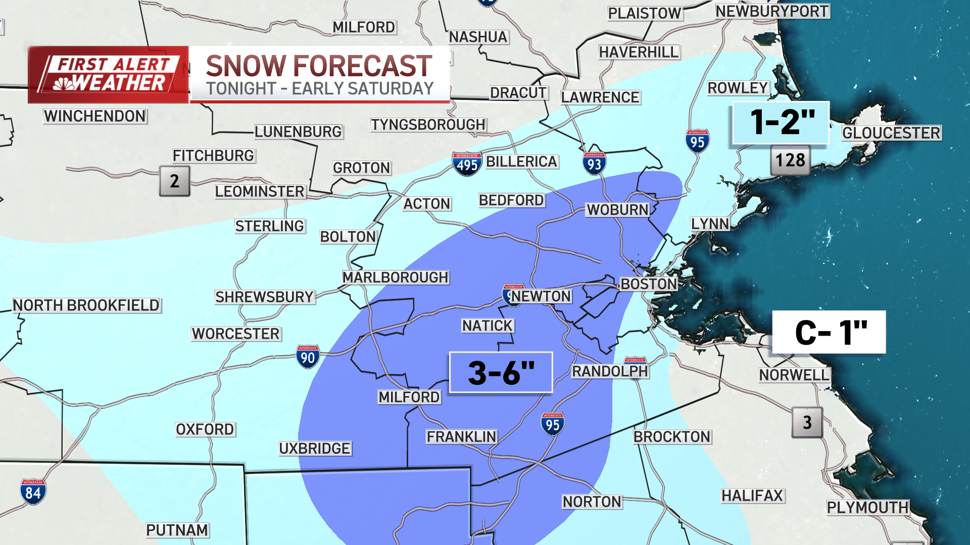
Snow continues to fall across Boston, and our snowfall projections have now increased based on radar trends and the way a coastal low has shifted a trough a bit more north.
So we're now looking at around 3 inches of snow for Boston on Friday night through daybreak Saturday. Isolated spots will get 4 inches of snow (northeastern inland Massachusetts, and interior Plymouth County).
Boston snowfall totals
And it looks like the snowfall projections are only continuing to rise.
Coastal front has set up in SE Mass. Some spots will get 3-6” along that zone. Temps slowly falling. pic.twitter.com/7R2GlGSvO1
— Pamela Gardner NBC10 Boston (@Pamelanbcboston) December 20, 2024
This precipitation will flip to rain, and a mix, then back to snow after sunset as temperatures go from the upper 30s to around freezing. Inland areas will also trend near 3 inches of snow inland in eastern Massachusetts, while the immediate coastal towns will see less due to the warmer ocean water influence.
Winter weather advisory in Boston
A winter weather advisory is in effect for Greater Boston through 4 a.m. Saturday. Click here for the latest severe weather alerts.
The impact of this snowfall is higher compared to most minor snow events due to it being a Friday before Christmas and the evening commute.
Friday night’s lows drop to the 20s, and this allows icy spots to develop. Thanks to a northwest breeze, our wind chills sink to the single digits and teens.
Winter solstice 2024
Afternoon highs reach the low 30s, with sunshine for Saturday as we see the winter solstice at 4:21 a.m. Ocean-effect flurries are possible across the outer Cape too on both days this weekend.
Sunday we fall even more to highs in the 20s with more winter sunshine.
Next week, we’re looking at some light snow on Christmas Eve, to a wintry mix on Christmas Day. At least some festive flakes for Christmas Eve mass around New England.
Temperatures rebound a bit to the low and mid 30s through midweek next week.

