Heavy flooding rain and damaging wind gusts continue to pound the region as an intense area of low pressure crosses the Northeast on Monday.
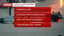
Flash flood warnings were issued in New England Monday, but most have since expired. Warnings will remain in effect in for parts of western Maine until early Tuesday morning. See all weather alerts in your area here, and check school closings here.
WATCH ANYTIME FOR FREE
Stream NBC10 Boston news for free, 24/7, wherever you are. |
Here's a closer look at some of the potential impacts:
Get updates on what's happening in Boston to your inbox. Sign up for our News Headlines newsletter.
Power outages
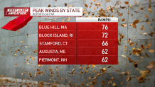
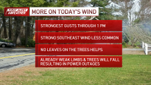
The wind has been howling out there -- numerous gusts of 45-55 mph, with localized gusts of 60-70 mph have resulted in areas of tree damage and scattered outages. I expect the power outage numbers to climb and peak by early afternoon.
Local
In-depth news coverage of the Greater Boston Area.
Powerful wind gusts continue
After 1pm, gusts will ease to 25-35 mph although it will take until late afternoon on Cape Cod for the wind to throttle back a bit.
Already on Monday morning, the wind gusts were strong enough to lead to a ground stop at Boston Logan International Airport.
Flash flooding, coastal flooding possible
Meanwhile rain will continue at times through the mid afternoon, with localized areas of flash flooding and isolated thunder possible. Rain tapers off and ends between 3-5 pm south to north. Additional rainfall amounts of either side of ½” are likely with 1-2” from north central NH into much of Maine. Rivers and streams are on the rise and minor to moderate flooding is occurring or forecast. Expect pockets of minor coastal flooding as well through early afternoon with moderate pockets along Narragansett Bay and in Providence.
What's next?
Temperatures in the 50s will cool into the 30s gradually on Monday night, but thankfully remain above 32, so there are no concerns about ice. Tuesday, the sun returns and cooler air arrives: expect highs in the 40s (30s in Vermont and the far North Country).
Some snow showers will push through western and northern Vermont and far northern New Hampshire, dropping a coating to an inch or two with elevation.
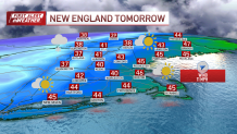
Otherwise, our weather pattern will be quiet and seasonable right on through Christmas Day with highs generally in the upper 30s to low 40s. The middle of next week features the risk of some wet weather returning, along with some milder air.


