
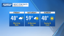
Highs will be in the upper 40s Friday. Watch the video to see what else to expect.
It’s the first day of astronomical spring! And it’s been somewhat of a typical New England spring already. In fact, we’ve seen a lot of clouds around the region, along with areas of fog along the coast. And our temperatures have been fairly cool.
But as we continue moving through the day, the clouds will thin out enough to see some peeks of sunshine. High temperatures will be in the low to mid 50s.
WATCH ANYTIME FOR FREE
Stream NBC10 Boston news for free, 24/7, wherever you are. |
Thursday night, a cold front will swing through our area, giving way to rain mainly after midnight through the morning drive on Friday. Some pockets of heavy rain are possible at times. A quarter to one-half inch of rain is possible.
Some snow could mix in with rain into Friday for parts of northern New England, but for Greater Boston it’s mainly rain.
Get updates on what's happening in Boston to your inbox. Sign up for our News Headlines newsletter.


The chance for rain will diminish by afternoon, leading to some areas of sunshine. Our winds will be picking up from the northwest, gusting to 35 mph. Those northwest winds will keep our temperatures in the upper 40s by Friday afternoon.

Saturday will be warm and breezy. Southerly winds will boost our highs into the upper 50s and lower 60s. We’ll see partly to mostly cloudy skies.
Sunday will be cool again, with highs in the upper 40s.
More rain moves in with a cold front into Monday. Again, some snowflakes could mix with the rain for parts of northern New England.
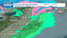
High temperatures will be near 50 in Boston on Monday afternoon.
