
Rain and snow are expected across New England Saturday morning. Watch the video to see what else to expect.
The unsettled weather is here to stay. All. Weekend. Long. A coastal low is taking shape just south of New England and this brings us a gloomy, windy, chilly, and rainy (or snowy) weekend.
How much snow did we get on Friday?
Stream NBC10 Boston news for free, 24/7, wherever you are.
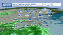
The snowfall Friday morning was on track with higher elevations receiving 1-3 inches of wet spring snow on grassy surfaces while the roads remained wet and not white. The snow has already melted away for most. The clouds and some drizzle will be around all afternoon and evening as our temps stay in the 40s.
Get updates on what's happening in Boston to your inbox with our News Headlines newsletter.
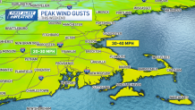
An onshore breeze picks up a bit as a coastal low forms this evening. After 7 p.m., some bands of rain will head in from the south. And once the rain passes over the Berkshires or Worcester Hills, we see a mix to snow. J
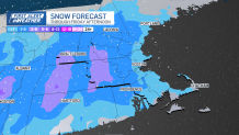
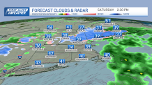
What parts of New England will see snow Saturday?
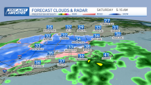
Just like last night and this morning, Saturday morning brings us fresh snow in grassy areas with wet roads. Around 1-3 inches of snow is in the forecast for the same areas in high terrain.

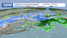
Rain showers continue for Boston through midday. The northeast wind will be as high as 30 mph, keeping drizzle, clouds and temps in the upper 30s at the shore, 40s inland.
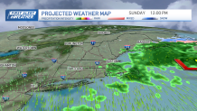
More rain for some on Sunday
The offshore storm heads toward the southern Gulf of Maine for Sunday, but the eastern half of New England continues to see wet weather. Highs stay in the low 40s, with a more northerly wind late day.
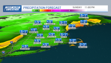
Scattered showers, drizzle, clouds continue for Boston and anywhere inside Interstate 495, with light snow showers in interior Maine. Head west if you want milder temps and glimpses of sun. Highs in the Champlain Valley reach the mid 50s with late sun.
Monday and Tuesday we see drier air, sun and warmer temps, with highs in the 60s. A couple showers are possible for Tuesday, then we dry off again for Wednesday and Thursday.
Friday through Easter weekend again looks rainy. The timing and how much rainfall is still TBD. A cutoff low seems to take shape Friday, meaning a gloomy weekend. But stay tuned -- hopefully this will change between now and then.
