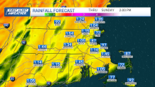
We’re not seeing a washed-out weekend, but there are some challenges ahead. Clouds will snuff out any sun today as they lower and thicken ahead of our storm. Since we started relatively cold, we’ll stay relatively chilly this afternoon. Highs will only make the mid-40s. Winds will also freshen from the southeast this afternoon.
The brunt of the rain will fall overnight, and some of it will once again be intense. All told, we’re projecting at least an inch of water for most, maybe a little more in spots depending on whether the downpours hit your community more than once.
WATCH ANYTIME FOR FREE
>Stream NBC10 Boston news for free, 24/7, wherever you are. |

Gusts will ramp up to near 50 at the coast piling water up along the coast for the noontime high tide. Once again, the focus for moderate (possibly major) flooding will fall to Cape Ann, Newburyport, Salisbury, Hampton, Rye, and the Maine coast. Thanks to the protection of Cape Cod, both the North Shore (south of Gloucester) and the South Shore will be spared any moderate flooding, but we can still expect minor flooding in these areas – including Morrissey Blvd and the Harborwalk in Boston – both before and after noontime.
Get updates on what's happening in Boston to your inbox. Sign up for our >News Headlines newsletter.
Winds shift to the west by late morning, limiting the flooding for the late-night tide Sunday. As these winds continue to howl through Monday with the storm deepening near Nova Scotia, we could again see gusts near 40 at times. This will be a chilly day too, with occasional flurries or snow showers crossing from time to time.
The chill is on its way out as early as Tuesday with a shift in the upper-level winds. We’ll see a gradual warming trend AND a rain-free forecast for several days. Our next chance at precipitation might not be until NEXT weekend.
I think I buried the lead there. 😊
Local
In-depth news coverage of the Greater Boston Area.
Enjoy the weekend and be safe!


