
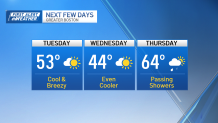
Tuesday will be mild and mostly sunny. Watch the video to see what else to expect in the days ahead.
Hang on! The sun will return soon. Until then, though, we’ve got to deal with one more gloomy day and a batch of rain Monday night.
As we move through this Monday, expect cloudy skies and areas of patchy fog. Southerly winds will boost our high temperatures into the low to mid 60s.
WATCH ANYTIME FOR FREE
Stream NBC10 Boston news for free, 24/7, wherever you are. |
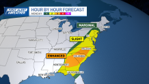
We’re watching a cold front that’s moving across the country. This front is forecast to produce a round of severe storms, with potential tornadoes and damaging wind gusts, over the South, the Mid-Atlantic and parts of the Northeast on Monday.
Get updates on what's happening in Boston to your inbox. Sign up for our News Headlines newsletter.
However, as the front slides into New England on Monday night, we’ll likely see scattered rain and perhaps a thunderstorm or two. The threat for severe weather remains low here.However, some storms could produce periods of heavy rain at times. Remember, turn around, don’t drown. Never drive through flooded streets.
The rain will continue overnight into early Tuesday morning. The rain should clear our area before 7 a.m. Then we’ll see clearing skies and bright sunshine through the afternoon. High temperatures will cool into the lower 50s.


On Wednesday, we’ll see more sunshine, but the day will be a touch cooler. The high temperatures will be in the mid 40s.

Clouds will increase Wednesday, all ahead of our next weather maker. A frontal system will push toward New England into Thursday. A few passing showers are possible on Thursday.
But more wet weather arrives on Friday for the Red Sox home opener at Fenway. High temps will climb into the mid to upper 60s on Thursday and Friday.
Some rain is also expected this weekend, particularly on Sunday. Highs will cool into the 50s for both Saturday and Sunday.
