Snow will fall throughout New England Thursday, with more coming this weekend. Watch the video to see what to expect.
The first in a parade of winter storms is headed to New England this Thursday.
Snow will kick in around 8 a.m., with coverage and intensity increasing through noon — leading to the heaviest snowfall and the most widespread travel slowdowns mid-morning.
WATCH ANYTIME FOR FREE
Stream NBC10 Boston news for free, 24/7, wherever you are. |

Winter weather advisories have already been issued for parts of the region, and some school closures have also been announced.
Get updates on what's happening in Boston to your inbox. Sign up for our News Headlines newsletter.

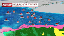
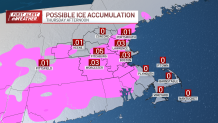
By the afternoon, as the storm begins to wind down, but warming air aloft will mix in some ice. Although significant ice accumulations aren’t expected, isolated spots could see a glaze of .001 to 0.1 inches of ice between 1 and 4 p.m., resulting in a slippery end to the snowy day.
In total, the snowfall (with some sleet mixed in) will add up to between 2 and 4 inches from Boston to central Massachusetts and southern New Hampshire.
How much snow will we get in Massachusetts, New Hampshire?

Another storm expected this weekend
Local
In-depth news coverage of the Greater Boston and New England area.
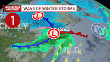
Looking ahead, another winter storm is slotted for late Saturday into Sunday after Friday and a majority of Saturday will be mainly dry.
Wednesday could bring more snow to Greater Boston
Then next up is the potential for snow Wednesday of next week. Stay tuned for updates on NBC10 Boston as these systems evolve for updated snow totals and impacts.
Track the storms with live radar

