
Wintry weather is possible through the weekend. Watch the video to see what to expect.
The tranquil conditions Thursday and calm skies will turn cloudy and overcast around sunset. This will be the intro to the first of three wet weather systems this weekend. The first will be the colder of the trio.
How much snow will we get in Mass., NH?
Stream NBC10 Boston news for free, 24/7, wherever you are.
Upper air temperatures will run a few degrees colder than normal and be around 28 degrees. This will be just enough for the formation of snow above our heads... however, surface temperatures will tote the line of 33-35 degrees.
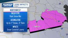
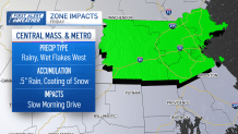
While the grass and metal surfaces will be colder, road temperatures will remain above freezing, so only patchy coatings are expected along Interstate 495 through Lawrence and Lowell.
Get updates on what's happening in Boston to your inbox with our News Headlines newsletter.
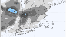
With elevation, the Monadnock Region and Worcester Hills will have about an inch of snow between midnight Friday and mid-morning. Higher accumulations will be expected through the Connecticut River Valley of southern Vermont and the Berkshires, between 1-2 inches.
While a few flakes and sleet will be possible, accumulating snow shouldn’t be anticipated in Boston, as the rain and warm air takeover. In total, this will end roughly around noon on Friday as cold becomes the focus of the day. High temperatures remain below average, near 48 degrees.
Friday storm impacts, by zone

The wet weekend ahead
Local
In-depth news coverage of the Greater Boston and New England area.


Clearly after being in drought since the fall, we’ve begged for rain. And now our weekend cup overflows.
We’ll have two rainmakers that’ll put a damper on Saturday and Sunday. Neither seem to promise too much of a break, but Saturday’s storminess comes in along a warm front, as temperatures gradually swing into the mid 40s at the coast.
The low pressure to the south will draw in colder temperatures for central Massachusetts. Patchy coatings of snow and slush will favor higher terrain and through the Worcester Hills. Rain totals for southeastern Massachusetts and Rhode Island are near half an inch, with Cape Cod and the Islands near an inch.
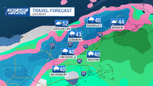
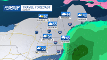
Sunday won’t be the same storm complex, but the final of three for this stretch. This passes close to but south of southern New England, keeping rain across coastal Massachusetts, and about 10-20 miles inland, inside of I-495.
The day will gradually dry from west to east, thus western Massachusetts and central Vermont will actually have sun and highs in the 50s, though Boston will still be in the 40s for afternoon highs.
We really needed the rain
You’re probably staring at your lawn, and while it isn’t crispy, we did need the rain. Topsoil has fared well with the recent rain, but the drier layers are embedded beneath and are a sign of last summer and fall. Our drought debt accrued then, and we’re still paying interest on that.
@tevin_wooten Gonna have to make it rain a few bands before our drought is gone! ☔️ 💰 The situation is improving but we’ve got a way to go! #nbc #boston #weather #drought @NBC10 Boston ♬ Rapid swish - unknown