
Expect a cold, wet, and windy weekend as we track another system moving in. Here’s your First Alert forecast.
Follow NBC10 Boston:
https://instagram.com/nbc10boston
https://tiktok.com/@nbc10boston
https://facebook.com/NBC10Boston
https://twitter.com/NBC10Boston
https://bsky.app/profile/nbcboston.com
It’s not pretty. And it’s hard to put a positive spin on a cold, rainy weekend, but here we are looking for any possible dry times or glimmers of hope.
Some snow early Friday morning
Stream NBC10 Boston news for free, 24/7, wherever you are.
The last of the flakes and showers from today’s event will move out this morning, leaving us with a damp, drizzly afternoon. Despite that, our temperature recovery will be…OK -- highs in the mid and upper 40s.
Tonight, a storm will spin off the southern tip of Maryland and move south of Nantucket by Sunday morning. This is the reason for our wet – and somewhat snowy- weekend.
Get updates on what's happening in Boston to your inbox with our News Headlines newsletter.
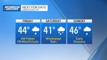
Rain, more snow this weekend
Local
In-depth news coverage of the Greater Boston and New England area.

While cold will be sequestered to the higher terrain of central and western Mass., we could see some flakes or sleet mix in inside I-495 into early Saturday.
The afternoon will see predominately rain with some spotty mix in the Worcester Hills. It’s here that we have a better chance of seeing some accumulation through early Saturday.

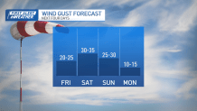
Since this is a coastal storm, there will be wind on Saturday.
Gusts could top 30-35 mph along the coast. Yay.
Sunday isn’t dry, but it isn’t looking as washed out as Saturday. Early showers will give way to sprinkles in the afternoon. There’s a remote possibility that we see the sun before it sets, especially west of Boston.
Of course, Monday will see a return to the sun and milder temps. We’ll build on that for Tuesday, with the possibility of hitting 60 in spots.
Weather aside, make it a great weekend.