A bit of a cooldown is ahead. Watch the video to see what else to expect.
We have a typical New England spring day Wednesday with a tale of the Haves and The Have Nots. An east wind has blown in clouds already to the South Shore, the Cape and islands on a northeast wind. This will keep our temps in the 40s for the rest of the day, with drizzle developing at the coast by sunset.

WATCH ANYTIME FOR FREE
Stream NBC10 Boston news for free, 24/7, wherever you are. |

Meanwhile, 20 miles inland we have abundant sunshine and highs in the 60s. Everyone will see increasing clouds Wednesday night into Thursday as specks of drizzle and fog take over. Highs remain in the 50s to 60s northwest for Thursday. By the way, Thursday at 5:01 a.m. the Spring Equinox occurs... happy Spring!
Get updates on what's happening in Boston to your inbox. Sign up for our News Headlines newsletter.
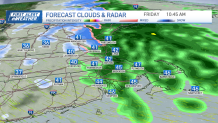
Friday will feel more late winter-ish, with some flakes mixing in with rain showers. The rain will be in New England on Friday morning predawn, with snow showers in higher elevations. The snow throughout the day does battle the high sun angle, and a thawed ground. So scattered coatings to 3 inches of snow at the mountain peaks can be expected through Friday night. The rest of the northeast will see rain.
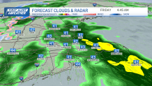

The storm wraps up early afternoon with cold air from the northwest. This switches Boston to the wet snowflake mix briefly before exiting. It gets quite windy Friday evening with northwest gusts 40-50 mph.
Local
In-depth news coverage of the Greater Boston and New England area.


Then the wind will be around 30 mph from the west on Saturday. But thankfully highs reach the 50s to low 60s with sunshine.
Cooler temps return Sunday with highs in the mid 40s. Our next storm system may move in Monday as a surface low develops. Depending on the track, we may see rain to snow, but stay tuned since this can still change.