
It’s been great seeing the sunshine for the past couple of days! But as the old saying goes, all good things must come to an end. And what an abrupt end it will be! We’re tracking more wet weather on the way, and guess what? It arrives just in time for the weekend…again!
But today, let’s enjoy the weather. We’re tracking a mix of sun and clouds in the Greater Boston area on this Thursday. Southerly breezes will help boost our afternoon temperatures into the upper 40s and lower 50s. Much of the day will be dry, but our clouds will increase and thicken through the evening, giving way to some wet weather late tonight into Friday morning.
Stream NBC10 Boston news for free, 24/7, wherever you are.
When will it rain? Will there be a wintry mix?
Get updates on what's happening in Boston to your inbox with our News Headlines newsletter.
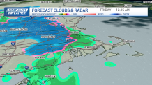
A low pressure system will push rain our way late tonight. Some sleet and snowflakes could mix with the rain into early Friday morning. Right now, with our temperatures staying above freezing in Boston, we don’t expect too many problems. We’ll need to keep an eye on communities toward Worcester Hills and southern New Hampshire where some light accumulations could develop, especially on elevated and grassy surfaces.
By Friday afternoon, much of the rain is gone. High temperatures will be in the mid 40s Friday.
The rain pushes back into the area by Friday night, setting us up for a rather rainy weekend.


Weekend weather forecast
Local
In-depth news coverage of the Greater Boston and New England area.


In fact, on Saturday, rain is likely in the area. Some of the rain could be heavy at times. No severe weather is expected. Otherwise, expect cloudy skies and highs in the low 40s.
Rain will continue over parts of Eastern Mass. on Sunday. Highs will be in the upper 40s.
Drier weather moves in on Monday and Tuesday as highs climb into the 60s.