
While severe weather is not expected in New England, the same system that wreaked havoc across other parts of the US is moving in overnight and sticking around most of Monday. Here’s your First Alert forecast.
Follow NBC10 Boston:
https://instagram.com/nbc10boston
https://tiktok.com/@nbc10boston
https://facebook.com/NBC10Boston
https://twitter.com/NBC10Boston
https://bsky.app/profile/nbcboston.com
It was overcast but mostly dry in New England on Sunday, and we've issued a First Alert for a stormy St. Patrick's Day Monday.
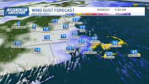
The south wind over the cold ocean carries in more moisture and warmth (meaning more clouds, fog, drizzle). A spot shower chance remains all day long. Wind ramps up to south gusts of 20-30 mph this afternoon and evening Worcester Hills will be around 40 mph. This helps to boost highs to the mid 60s, 50s south coast despite the clouds. Temps stay in the 50s tonight as heavy rain moves in.
WATCH ANYTIME FOR FREE
Stream NBC10 Boston news for free, 24/7, wherever you are. |
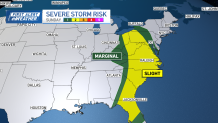
Severe weather Sunday heads into the eastern U.S. with a “slight risk” for tornadoes, damaging wind & hail. We don’t expect severe storms tonight but there will be a rumble of thunder and some lightning as a line of storms moves through around 4 a.m. for Boston. Wind increases to 40-45 mph in higher elevations and along the coast.
Get updates on what's happening in Boston to your inbox. Sign up for our News Headlines newsletter.
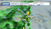
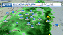
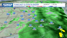
Rain continues through Monday morning into the afternoon as a surface low develops. This keeps our shower activity around for longer Monday, St. Patrick’s Day. Temps fall to the 40s as our wind shifts and the rain heads out in the evening.
Timing and impacts of heavy rain

Temps will be in the low 50s on Monday with a light north breeze and sunshine. A light east wind keeps temps around 50 in Boston with near 60 degree highs inland on Wednesday. Clouds and late night showers bring in more 50s for Thursday, cooling to the 40s Friday. Sunshine returns with highs in the 50s both days next weekend.