
Highs will be in the low 40s Friday, but snow is expected in parts of New England.
Buckle up, Boston! Our roller coaster ride of temperatures continues. We’re also tracking more rain and snow on the way.

WATCH ANYTIME FOR FREE
Stream NBC10 Boston news for free, 24/7, wherever you are. |
As we continue moving through this Thursday, expect plenty of sun, but don’t let the sun fool you! It’s cold out there. High temperatures will be in the upper 20s, but feels-like temperatures will be in the teens for most due to gusty west winds. Winds could gust to 25-30 mph. Thursday night, expect increasing clouds and low temperatures in the 20s.
On Friday, southerly winds should help temperatures warm into the upper 30s and lower 40s.
Get updates on what's happening in Boston to your inbox. Sign up for our News Headlines newsletter.

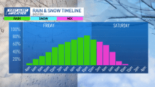
Unfortunately, we won’t be able to enjoy the “warmer” temperatures with sunshine. In fact, a frontal system from the south will push north, spreading rain across central and eastern Massachusetts for much of the afternoon and evening.

However, late Friday night, some of the rain could transition to a rain/snow mix as colder weather rushes in. Some light snow accumulations are possible for communities well north of the Massachusetts Turnpike, in particular those closer to the Massachusetts/New Hampshire state line. Areas south of the Mass. Pike will generally see rain Friday and Friday night.

As the system begins to exit the region, a few flurries could develop for Boston into the early Saturday morning, mainly before dawn.

Talking about Saturday, much of the day will be dry. We’ll see some clearing. Highs will be in the mid 30s. Sunday will be cold, too, with highs in the lower 30s.
Local
In-depth news coverage of the Greater Boston and New England area.


By Sunday night, another weather system will swing by New England, giving way to a mix of rain and snow. Parts of northern New England will have the best snow accumulations, but a mix is possible here in Greater Boston into early Monday.
High temperatures will be in the 40s on Monday, then back into the 30s Tuesday and Wednesday.
