
Buckle up! We’re in for a quite a roller coaster ride with our temperatures this weekend here in New England. And to add insult to injury, Mother Nature will deliver a wintry mix for some, too.
A frontal system will stall across Massachusetts on Saturday, giving way to two different seasons in just one day!
Stream NBC10 Boston news for free, 24/7, wherever you are.
Get this! High temperatures will likely fall from the 40s early Saturday morning into the 30s by afternoon in Boston. Why, you ask? ell, we’ll be on the northern side of the front, and with easterly winds coming off the ocean, our temperatures will stay pretty chilly.
Temps in the 70s Saturday for some
Get updates on what's happening in Boston to your inbox with our News Headlines newsletter.
However, if you’re hitting the road to Connecticut or New York on Saturday, you’re going to notice a huge difference! It’s going to feel a lot more like spring. In fact, those areas will be on the southern side of the stationary front, producing high temperatures for some in the 70s.

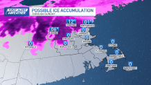
Now, let’s talk about the wet weather. Much of the Boston area will see periods of rain on and off as we move through Saturday. However, some sleet or freezing rain could develop Saturday toward Worcester Hills and into southern New Hampshire.


How much snow could we get to the north?
Little to no accumulation is expected at this time, but we’ll keep an eye on it. If your travels take you toward northern New England, stay alert. The likelihood for accumulation snow and ice is higher.
On Sunday, the front will drift farther south, giving way to chilly, raw conditions for much of New England. High temperatures in Boston will be in the 40s. Again, we’ll see clouds and scattered showers. There will likely be some breaks in the rain. The best rain chance will likely arrive Sunday evening into Monday.

By Monday, a cold front will move in from the west. Ahead of the front, our temperatures will soar into the mid 60s due in part to southerly winds. Unfortunately, it will be tough to enjoy the 60s with a walk in the park Monday because we’re expecting even more rain. And we can’t rule out a rumble of thunder.

Through Monday, some areas could potentially see up to an inch of rain or more.
Local
In-depth news coverage of the Greater Boston and New England area.


Cooler weather moves in by Tuesday. Highs will be near 50. Then we’ll be in the low 40s by Wednesday.