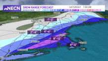
A major winter storm brought a widespread area of accumulating snow to the region, with over a foot of snow reported in portions of southern New England!
Though the storm wasn’t expected to bring this much snow, we did see a heavy band of snow set up at the onset over Connecticut and Rhode Island, which enabled the system to pump out an incredible 1 to 2 inch snowfall rates per hour!
WATCH ANYTIME FOR FREE
>Stream NBC10 Boston news for free, 24/7, wherever you are. |

The good news is that the system is moving fast, and many areas will see clearing through Friday evening as low pressure rapidly pulls away from the region. In the storm’s wake, we’ll see temperatures plummeting into the teens south and single digits north, with a gusty northwest wind making it feel much colder.
Get updates on what's happening in Boston to your inbox. Sign up for our >News Headlines newsletter.
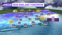
Saturday will feature a good deal of sunshine, with cold temperatures and a biting wind. Highs reach the upper 20s south and upper teens to mid 20s north, with the wind making it feel a bit colder.

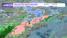
Clouds increase Saturday night, with temperatures holding steady. By Sunday morning, another system approaches from the west delivering rain/snow at the onset south with a few slick spots during the morning inland, switching to a plain rain showers by the afternoon.
It’ll remain mostly snow across the north, where colder temperatures will hang on. Highs Sunday push 40 south and the 30s north.

The latest on the storm:
- Full details on the storm
- Live view from Boston's Seaport
- Latest timeline, expectations
- Road conditions, reported crashes
- Snowfall totals
- Snowstorm photos

