There will be widespread snowfall Saturday night into Sunday. Watch the video to see what else to expect.
A weekend storm will affect travel all across the northeast as we kick off school winter vacation week next week and Presidents Day weekend.
Valentine’s Day
WATCH ANYTIME FOR FREE
Stream NBC10 Boston news for free, 24/7, wherever you are. |
Temps stay in the 20s through sunset, but it will feel like the upper teens thanks to a persistent gusty northwest wind. Gusts up to 50 mph subside around sunset and we have only a light breeze by overnight. Lows drop to 10-20 degrees for much of New England as we start off nice and calm Saturday morning.

Get updates on what's happening in Boston to your inbox. Sign up for our News Headlines newsletter.
Snowstorm Timing
Saturday morning and afternoon looks cloudy, with temps in the 20s but dry. This is cold enough to support all snow with the onset of precipitation Saturday evening.
By 6 p.m., light snow develops in Boston, with steady snow through midnight for all of New England. Some 0.5 to 1 inches per hour snowfall rates are expected at times.


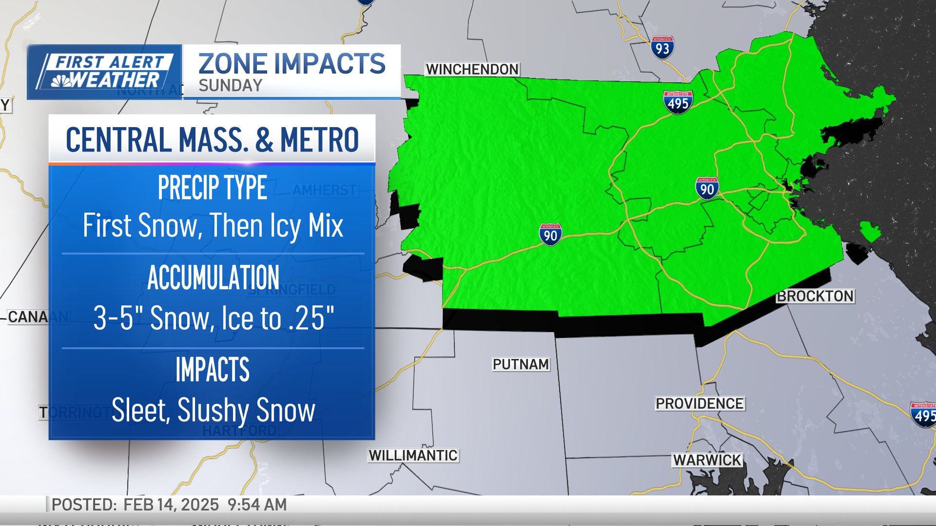
A nose of warm air aloft moves in from the south as the parent low pressure center moves over northwestern New England. This flips southern New England to sleet, then freezing rain around Sunday sunrise.


We keep freezing rain in the forecast outside of Interstate 495 and where cold air damming keeps temps from warming at the surface. This ice may add up to .2 to .3” of accumulation on top of the snow from overnight. Boston experiences ice mixing then, flipping to rain by Sunday afternoon with heavy rain around 1 inch the rest of the day.

Meanwhile, the ice and snow remains steady inland through Sunday evening.

Another thing to note is that a surface low develops around Long Island Sunday morning and this helps to inject a dry slot into southern New England. Light mist or freezing drizzle to fog may cut down on accumulations of ice. That surface low eventually takes over from the parent low pressure center and strengthens as it heads to the Canadian Maritimes Monday.
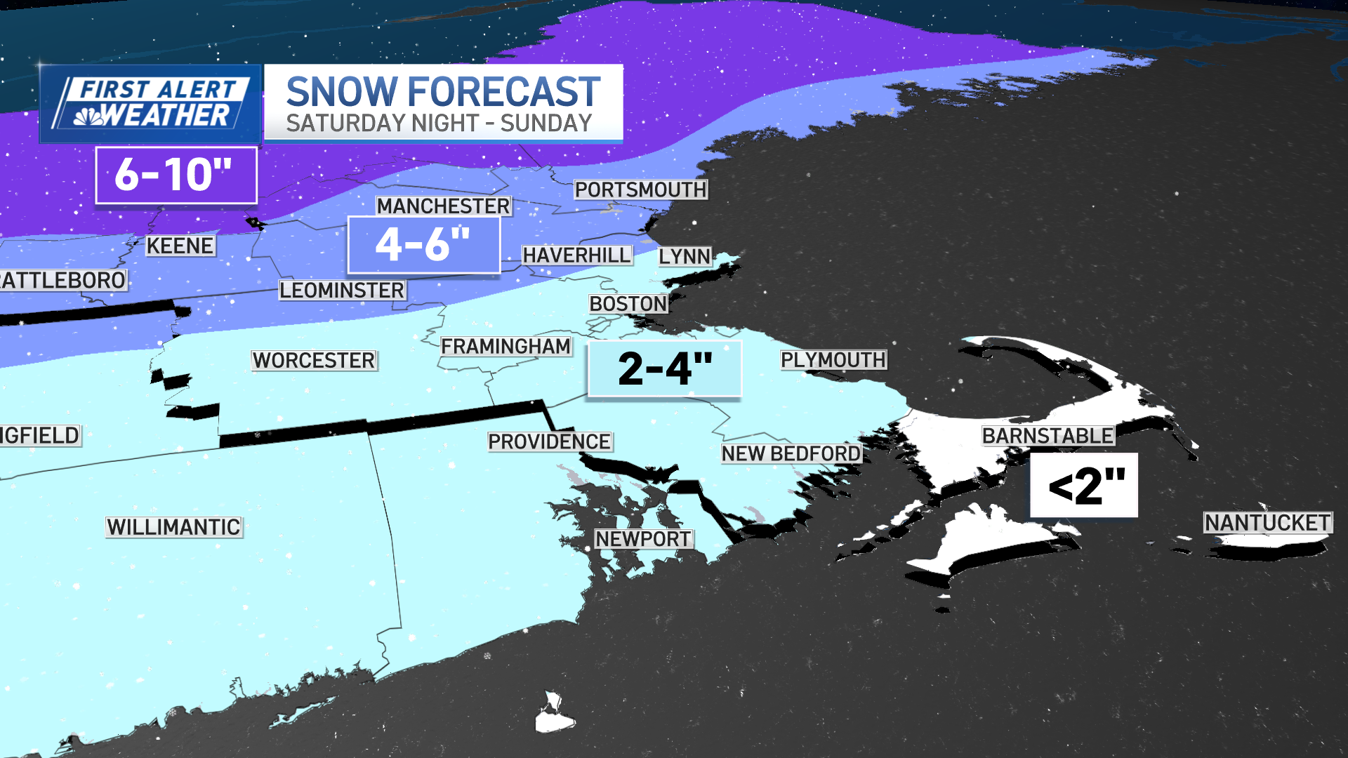
Snowfall totals in Massachusetts, ice accumulation expected

Saturday night we pick up 2-4 inches of snow for Boston, Providence, Hartford and Worcester, and less than 2 inches of snow on the South Coast, Cape Cod & Islands. About 4-6 inches of snow and sleet for are expected for the Merrimack Valley to Manchester, New Hampshire, and Brattleboro, Vermont. We're looking at 6-10 inches of steady snow for the whole event, from Saturday night to Sunday night for the mountains.


Ice of 0.2-0.3 inches Sunday midday for interior Massachusetts, Connecticut, to southern Vermont and New Hampshire on top of the overnight snow.
Any winter accumulation in Boston gets washed away by the Sunday afternoon rain.


Wind and coastal issues
The wind won’t be much of an issue in terms of damaging wind speeds, but nuisance wind -- yes. Saturday night will be east 5-10 mph, increasing to 20-30 mph by Sunday afternoon. The wind flips more northerly Sunday late day and picks up to 40 mph. On Sunday night into Monday our westerly wind may get damaging as numbers approach 50-60 mph. This is a result of the storm system pulling away during Monday and a large difference in pressure change between the deepening low across the Canadian Maritimes and high pressure west.
The wave heights aren’t an issue until Monday either, as we see offshore winds churn up waves of 5-10 feet.
Another snowstorm Thursday?
Colder temps take over for Monday through Tuesday with highs in the low 20s and overnight lows around zero.
We have a significant storm showing up on forecast guidance for the roughly Wednesday into Thursday timeframe. The track of the storm is not locked in, but there is a strong signal for heavy snowfall and a coastal storm setting up.
Stay tuned to our First Alert weather team for further updates.