Thursday and Friday will be mild ahead of a wet spell coming this weekend. Watch the video to see what else to expect.
Clouds begin to clear Wednesday evening, setting us up for a brighter and breezy Thursday. Highs will reach the upper 40s to low 50s—right on par with the seasonal average of 48 degrees.
Gusty northwest winds may top 20 mph during the day, but skies stay mostly sunny and dry. Another quick-moving disturbance may spark a few brief rain or snow showers Thursday night into early Friday, especially across the higher elevations, but any activity will be light and short-lived.
WATCH ANYTIME FOR FREE
Stream NBC10 Boston news for free, 24/7, wherever you are. |
Friday looks quiet and pleasant, with temperatures climbing into the 50s and a bit of a breeze.
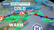
The weekend forecast is looking gray with on and off rain as a stationary front will be draped overhead. North of the front, likely much of Massachusetts and Rhode Island will stay stuck in the 30s and 40s, while parts of Connecticut and western Massachusetts have the chance to warm well into the 60s with a few 70s sprinkled in if they sneak into the warm sector.
Get updates on what's happening in Boston to your inbox. Sign up for our News Headlines newsletter.
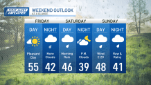
A few waves of low pressure along this boundary will bring on-and-off periods of rain from Friday night through Monday. It won't be a washout the entire time, but it will stay cloudy with the chance for sprinkles, at least, especially north of the front.

The Worcester Hills and southern New Hampshire could see this rain starting as a wintry mix/snow Saturday night into Sunday morning. A drying will begin Tuesday.