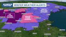
After a rainy, icy weekend, we’re looking ahead to another storm chance Monday night.
Follow NBC10 Boston:
https://instagram.com/nbc10boston
https://tiktok.com/@nbc10boston
https://facebook.com/NBC10Boston
https://twitter.com/NBC10Boston
https://bsky.app/profile/nbcboston.com
Sunday starts off cloudy and damp across southern New England, with drizzle, fog, and even some freezing drizzle possible early in the higher elevations of western and northern Massachusetts.
Most of the day will stay gray and chilly, with highs ranging from the 40s to near 50.
WATCH ANYTIME FOR FREE
Stream NBC10 Boston news for free, 24/7, wherever you are. |


Get updates on what's happening in Boston to your inbox. Sign up for our News Headlines newsletter.
A warm front lifting overnight into Monday will bring a round of moderate rain and warmer temperatures. Monday brings a dramatic temperature rebound, with highs jumping into the 60s ahead of a strong cold front. It will be breezy and mild, but also wet, with widespread showers, pockets of heavy downpours, and even a rumble or two of thunder possible in the evening and overnight into Tuesday.


Rain clears by early Tuesday, ushering in drier and cooler air for midweek. Highs will fall back into the 40s and low 50s Tuesday and Wednesday, before another system brings rain chances late Thursday into Friday.
Local
In-depth news coverage of the Greater Boston and New England area.
There’s still some uncertainty with the track of that system, but it could bring periods of wet weather into next weekend, along with a stark difference in temperatures between eastern Massachusetts and western Massachusetts.


