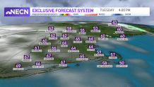
Spring temperatures have settled in as we started off rather mild Tuesday morning. Once the showers and clouds thin out from northwest to southeast, we will jump into the 60s and low 70s with some sun. Quite the turnaround!
In fact, the next several days we have a lot of “turn arounds,” as the forecast for one half of any day will be different from the second. Tuesday night’s lows will be in the 40s and 50s as more clouds head in.
WATCH ANYTIME FOR FREE
>Stream NBC10 Boston news for free, 24/7, wherever you are. |

A warm front heads in for Wednesday, bringing a few showers across northern New England. Southern New England will see more clouds around and temperatures in the mid 60s. With a cool south wind at the coast, the South Coast will stay in the 50s.
Get updates on what's happening in Boston to your inbox. Sign up for our >News Headlines newsletter.
Wednesday night with the warm front around we will keep an eye out for a couple thunderstorms. A frontal boundary (backdoor front) moves backwards toward southwestern New England onshore on Thursday.
This means more clouds and showers around but also a huge spread in high temperatures. For example, Hartford may reach 72 degrees (perhaps an 80 somewhere in the Connecticut River Valley), while Boston may be stuck in the upper 50s. This depends on how far inland the boundary pushes.
Thursday afternoon, more showers and thunderstorms move through, and some could produce strong gusty winds in western New England where temperatures are much warmer.
Local
In-depth news coverage of the Greater Boston Area.
Friday morning showers clear out in time for the Red Sox Home Opener. The weekend is split again with warm and dry weather Saturday (60s) and a chance for early showers Easter Sunday, breezy and cool in the 50s.
We are keeping close watch on Marathon Monday as showers may head in late into Tuesday and highs in the mid 50s. Most of the race seems to be dry, but stay tuned for timing updates.


