
Hurricane Milton brought an earlier-than-expected dose of chaos before it made landfall this week, as supercell thunderstorms — which feature rotating updrafts and can produce tornadoes — raced across the state.
The resulting twisters led the National Weather Service to issue 126 tornado warnings, and the agency’s Storm Prediction Center fielded 45 preliminary reports of tornadoes.
WATCH ANYTIME FOR FREE
Stream NBC10 Boston news for free, 24/7, wherever you are. |
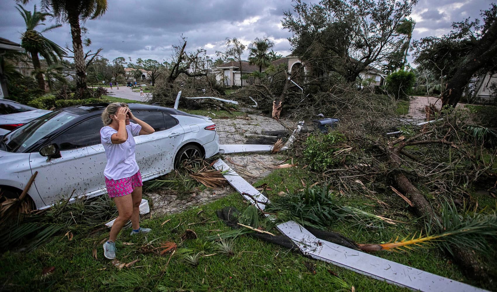
In St. Lucie County, five people died after a tornado tore through a retirement community, accounting for nearly a third of the 17 deaths reported as a result of the hurricane so far.
As Florida begins the long process of cleaning up and recovering from Hurricane Milton, the tornado outbreak has emerged as a leading cause of death and damage in a state that is accustomed to tropical storms, but less familiar with powerful twisters.
Get updates on what's happening in Boston to your inbox. Sign up for our News Headlines newsletter.
Likely to go down in Florida history as one of the worst tornado outbreaks ever observed there during a cyclone, the day included one of the strongest tornadoes in South Florida’s history.
The swirling winds hit 140 mph in Palm Beach Gardens, tearing away concrete walls and ripping off large sections of roof on newly built homes, according to a preliminary report from the National Weather Service.
“That’s the first EF-3 for our South Florida area, from Lake Okeechobee and southward, on record,” said Donal Harrigan, a NWS meteorologist in Miami. An EF-3 refers to a tornado with estimated winds of 136 to 160 mph (EF stands for the Enhanced Fujita Scale, which became operational for the National Weather Service in 2007).
It’s possible that several other observed twisters will rate as EF-3s after damage assessments, Harrigan added.
“You can probably count on one hand how many EF-3s there have been in the state, historically. We could potentially have multiple of them in one day,” he said.
This year overall, the U.S. has seen an abnormally high number of strong tornadoes linked to hurricanes.
Although tornadoes are common when hurricanes make landfall, most are on the weaker end of the spectrum; less than 1% of tornadoes associated with landfalling tropical systems have been rated EF-3 or stronger. This year, by contrast, four out of five hurricanes that made landfall in the U.S. produced EF-3-intensity tornadoes.
From 1995 through 2023, just five tornadoes produced by tropical storms were rated that high.
Hurricane Milton brought an earlier-than-expected dose of chaos before it made landfall this week, as supercell thunderstorms — which feature rotating updrafts and can produce tornadoes — raced across the state.
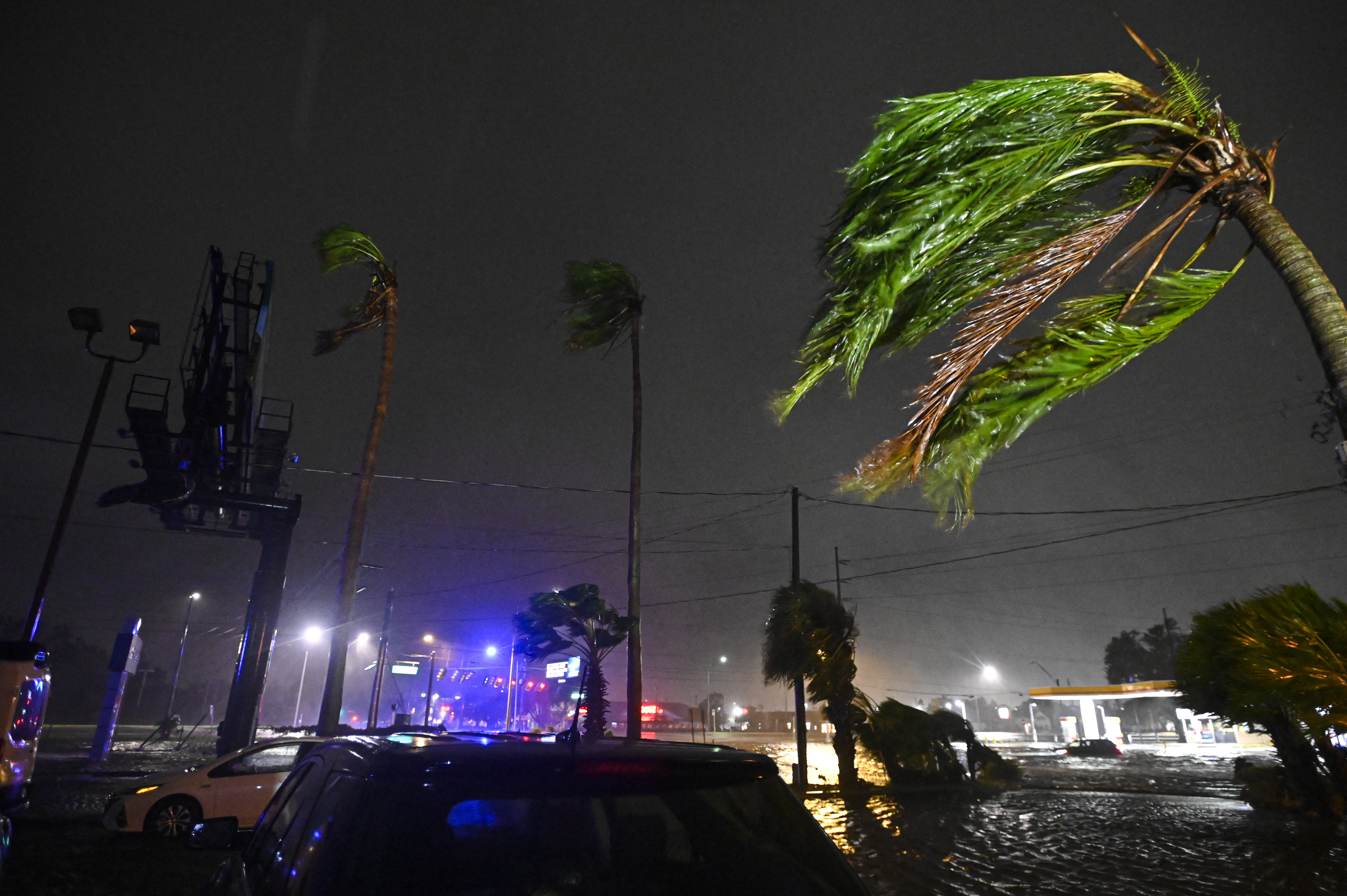
The resulting twisters led the National Weather Service to issue 126 tornado warnings, and the agency’s Storm Prediction Center fielded 45 preliminary reports of tornadoes.
In St. Lucie County, five people died after a tornado tore through a retirement community, accounting for nearly a third of the 17 deaths reported as a result of the hurricane so far.
As Florida begins the long process of cleaning up and recovering from Hurricane Milton, the tornado outbreak has emerged as a leading cause of death and damage in a state that is accustomed to tropical storms, but less familiar with powerful twisters.
Likely to go down in Florida history as one of the worst tornado outbreaks ever observed there during a cyclone, the day included one of the strongest tornadoes in South Florida’s history.
The swirling winds hit 140 mph in Palm Beach Gardens, tearing away concrete walls and ripping off large sections of roof on newly built homes, according to a preliminary report from the National Weather Service.
“That’s the first EF-3 for our South Florida area, from Lake Okeechobee and southward, on record,” said Donal Harrigan, a NWS meteorologist in Miami. An EF-3 refers to a tornado with estimated winds of 136 to 160 mph (EF stands for the Enhanced Fujita Scale, which became operational for the National Weather Service in 2007).
It’s possible that several other observed twisters will rate as EF-3s after damage assessments, Harrigan added.
“You can probably count on one hand how many EF-3s there have been in the state, historically. We could potentially have multiple of them in one day,” he said.
This year overall, the U.S. has seen an abnormally high number of strong tornadoes linked to hurricanes.
Although tornadoes are common when hurricanes make landfall, most are on the weaker end of the spectrum; less than 1% of tornadoes associated with landfalling tropical systems have been rated EF-3 or stronger. This year, by contrast, four out of five hurricanes that made landfall in the U.S. produced EF-3-intensity tornadoes.
From 1995 through 2023, just five tornadoes produced by tropical storms were rated that high.
Early research has suggested that tropical cyclones could produce more tornadoes in a warmer world. In a study published in June, researchers modeled hurricanes Ivan, Katrina, Rita and Harvey in a warmer, future climate. Their results indicated that the number of potentially tornadic storms produced by tropical cyclones could increase between 56% to 299% by mid-century, assuming the pace of fossil fuel pollution remains steady.
It’s not yet known whether climate change played a role in this year’s storm-related twisters. But Bill Gallus, an author of the June study and a professor of meteorology at Iowa State University, said that during Milton “it was really unusual how unstable conditions were in South Florida.”
Conditions are considered unstable when differences in density and temperature allow pockets of air to rise and fall rapidly — conditions that allow for thunderstorms.
“I was shocked when I pulled up the instability chart. It was as high as you’d see in Kansas on a storm chase,” Gallus said. “We have had hurricanes produce more tornadoes, but we’ve never had that many in just Florida.”
He added that in a warming world, this type of instability is “what we expect will become more common.”
One reason Milton produced so many tornadoes is that the hurricane’s thunderstorms ventured far from its center.
“With the initial tornadoes, that particular band of showers and storms from Milton seemed to really eject pretty far out in front of the hurricane,” Gallus said.
That outer storm band ended up isolated and without interference from other systems — those were the thunderstorms that spawned tornadoes. It’s a reminder that hurricanes can be a threat long before landfall and far from a storm’s center, experts said.
The other crucial ingredient for Milton’s tornadoes: heat. The hurricane approached the Florida coast in the afternoon, and because the thunderstorms were way out at the hurricane’s edge, they encountered especially warm conditions in addition to wind shear — changes in the direction and speed of winds at altitude. That allowed them to grow more powerful than they would in a more typical hurricane setup.
“The atmosphere had plenty of time to warm up,” Gallus said. “In most hurricanes, you don’t end up getting much heating from the sun at all, the tornadoes are happening in the thick of things in heavy rain.”
In a hurricane with winds that rotate counterclockwise, like Milton, tornadoes tend to form on the front end of a storm and on its right side — which is sometimes called the dirty side. This area also tends to see the worst of the winds.
That’s how it played out during Milton, Gallus said: The twisters “occurred right where we see most tornadoes happen.”
But in Milton’s case, he noted, the tornadoes were particularly concentrated.
Because of Milton’s short path across the Florida peninsula, Gallus said, “the real estate where it was producing tornadoes was small — I would guess it’s the most concentrated outbreak of tornadoes produced by a hurricane.”
More research is still needed on how, exactly, climate change can influence tornadoes produced by hurricanes. But global warming’s influence on extreme rain is more solid and clear.
A report released Friday from the World Weather Attribution project — a consortium of scientists that analyzes extreme weather and is considered an authority in determining climate change’s influence on particular events — found that rainfall in one-day events like Milton is now about 20% to 30% more intense because of climate change. The analysis found that Milton’s wind speeds were likely 10% stronger because of climate change’s influence.
The group similarly found that Hurricane Helene was more wet and windy because of climate change. Another preliminary report found that climate change likely boosted Helene’s rainfall by up to 50% over a three-day span in some of the areas hardest hit.
This story first appeared on NBCNews.com. More from NBC News: