
A chilly, breezy finish to the weekend leads us into a messy start to the new workweek in the Boston area.
After a gorgeous Saturday with highs in the low 60s, Sunday will be breezy and almost 20 degrees cooler. Highs in the 40s — just a bit below the typical mid-March average of 47 degrees — and clouds return overnight into Monday as our next weather system approaches.
WATCH ANYTIME FOR FREE
Stream NBC10 Boston news for free, 24/7, wherever you are. |

Track the chance for snow in the Boston area with our live radar:
Get updates on what's happening in Boston to your inbox. Sign up for our News Headlines newsletter.
Both Sunday and Monday mornings will be near if not just below freezing in the morning.
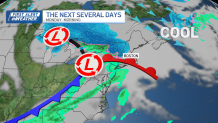
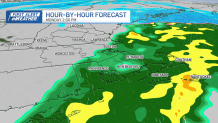
The system Monday morning will be a quick chance for snow accumulation for areas near Interstate 495. Across the Route 2 corridor, including the Worcester Hills, Berkshires and areas north and west, light snow amounts to coatings to 1 inch in high terrain.

Along the coast, any snow will be brief and slushy, quickly washed away by rain.
Monday will stay damp and raw, with highs in the upper 30s to mid 40s and steady showers lingering into the afternoon.
Conditions improve Tuesday with drier, calmer weather and seasonable temperatures in the 40s to low 50s.
Local
In-depth news coverage of the Greater Boston and New England area.


A weak system could bring some scattered showers Wednesday, with another chance for light rain or snow showers late Thursday into Friday.
Temperatures through the end of the week stay near or just slightly below normal, but we’re watching for a possible warmup next weekend as high pressure builds in — bringing a better shot at milder, spring-like air.