Over 8 inches of snow are possible in parts of the Greater Boston area and southern New Hampshire on Super Bowl Sunday. Here’s the latest on the timing and snow totals from the winter storm moving through New England.
Follow NBC10 Boston:
https://instagram.com/nbc10boston
https://tiktok.com/@nbc10boston
https://facebook.com/NBC10Boston
https://twitter.com/NBC10Boston
https://bsky.app/profile/nbcboston.com
Another snowstorm is hitting New England overnight Saturday into Sunday morning.
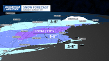
Many of us will get 5-8” of snow, with smaller totals southeast and higher totals across northern Massachusetts, southern Vermont and southern New Hampshire.
WATCH ANYTIME FOR FREE
Stream NBC10 Boston news for free, 24/7, wherever you are. |
See severe weather alerts in your area here.
Interactive weather radar:
Get updates on what's happening in Boston to your inbox. Sign up for our News Headlines newsletter.

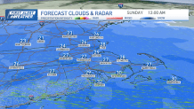
Snow timing:
We stay dry with increasing clouds Saturday afternoon and evening as temps reach highs in the mid 30s. They'll fall a bit to the upper 20s around Boston as the snow showers arrive in western New England between 7 and 9 p.m.
The snow arrives in Boston around 10 p.m. and, by midnight, we’re experiencing half to an inch of snow falling per hour.
The heavy snow continues through 3 a.m., but across the South Coast, Cape Cod and Islands, we see warmer air aloft and mixing to sleet or freezing rain.
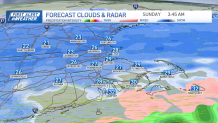
Meanwhile, across the Route 2 corridor, southern New Hampshire, Berkshires to southern Vermont, we keep the high snow rates and fluff through 7 a.m.
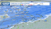
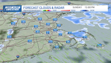
Between 7 and 9 a.m., the precipitation and snow tapers west to east. Only lingering snow at the eastern coast to flurries will be around for the afternoon. The rest of the day is dry.
Snowfall total predictions:
Most areas will be in the 5-8” range for snowfall totals.

Closer to Cape Cod & Islands, we mix to sleet and freezing rain, so less snow there, in the 3-5” range.
In northern Massachusetts, Route 2 corridor, Berkshires to southern Vermont and New Hampshire, we will be around 8" of fluffy snow.
The North Country will see 3-5” of fluffy snow, with the crown of Maine missing out on this storm.
Wind and coastal impacts:
This storm is all about the snow. There will be no damaging winds, no coastal flooding.
The southeast wind may gust up to 20 mph inland overnight, near 30 mph at the coast, Cape & Islands.
10-day outlook — more snow coming:
Our weather pattern remains active and unsettled through next week, with a few more storm systems bring the chance for more snow.

Around Tuesday night into Wednesday, there is a nearby storm bringing light snowfall.
A larger storm Thursday is tracking more north, so it looks like a wintry mix, snow in the mountains and a sloppy ice and rain event south.
A third upcoming system brings us snow, perhaps next weekend. Stay tuned!