
While we were waterproofing our weekend plans, a developing system off the East Coast became better organized.
Although there may be a name (Ophelia) assigned to the storm – along with fancy terms like Potential Tropical Cyclone or Subtropical Storm – the end result is the same: more rain. Just because it has a name doesn’t mean a call-to-arms to move boats, take in lawn furniture, look for sandbags, etc.
STAY IN THE KNOW
Watch NBC10 Boston news for free, 24/7, wherever you are. |
|
Get Boston local news, weather forecasts, lifestyle and entertainment stories to your inbox. Sign up for NBC Boston’s newsletters. |
Right now, it appears the steadiest showers will arrive by mid/late morning on Saturday and continue into the afternoon. Perhaps the biggest travesty of the weekend is that the sun will be in hiding for both days, and the highs will hover in the 50s.
Get top local stories in Boston delivered to you every morning. Sign up for NBC Boston's News Headlines newsletter.

As a whole, the entire timeline of the storm is wonky. Winds will be strongest WELL before the storm system ever approaches (thanks to the high to the north), and the rain will be heaviest WELL before the storm makes a move toward us. Ironically, when this system finally limps into New England by Monday, our greatest threat will be for more rain, not higher winds.

I’m not letting up my guard on heavy rain, however. Right now, it appears the Cape and Islands will see the highest amounts – perhaps as much as 2 inches. On Monday, there’s another threat for heavy rain as the storm system runs out of gas around New York City. Complex interplay with a stalled front could mean another renewed batch of heavy rain moving through the area. Details are few, but we have our eye on potential flooding.

Expected gusts for many will be subpar for ANY coastal storm system. The outer Cape, Nantucket, and Martha’s Vineyard may see speeds around 40 mph on Saturday, while the rest of us see feeble “gusts” near 20-25 at the coast, less elsewhere. Winds for the remainder of the weekend are steady from the east, but tolerable.
Weather

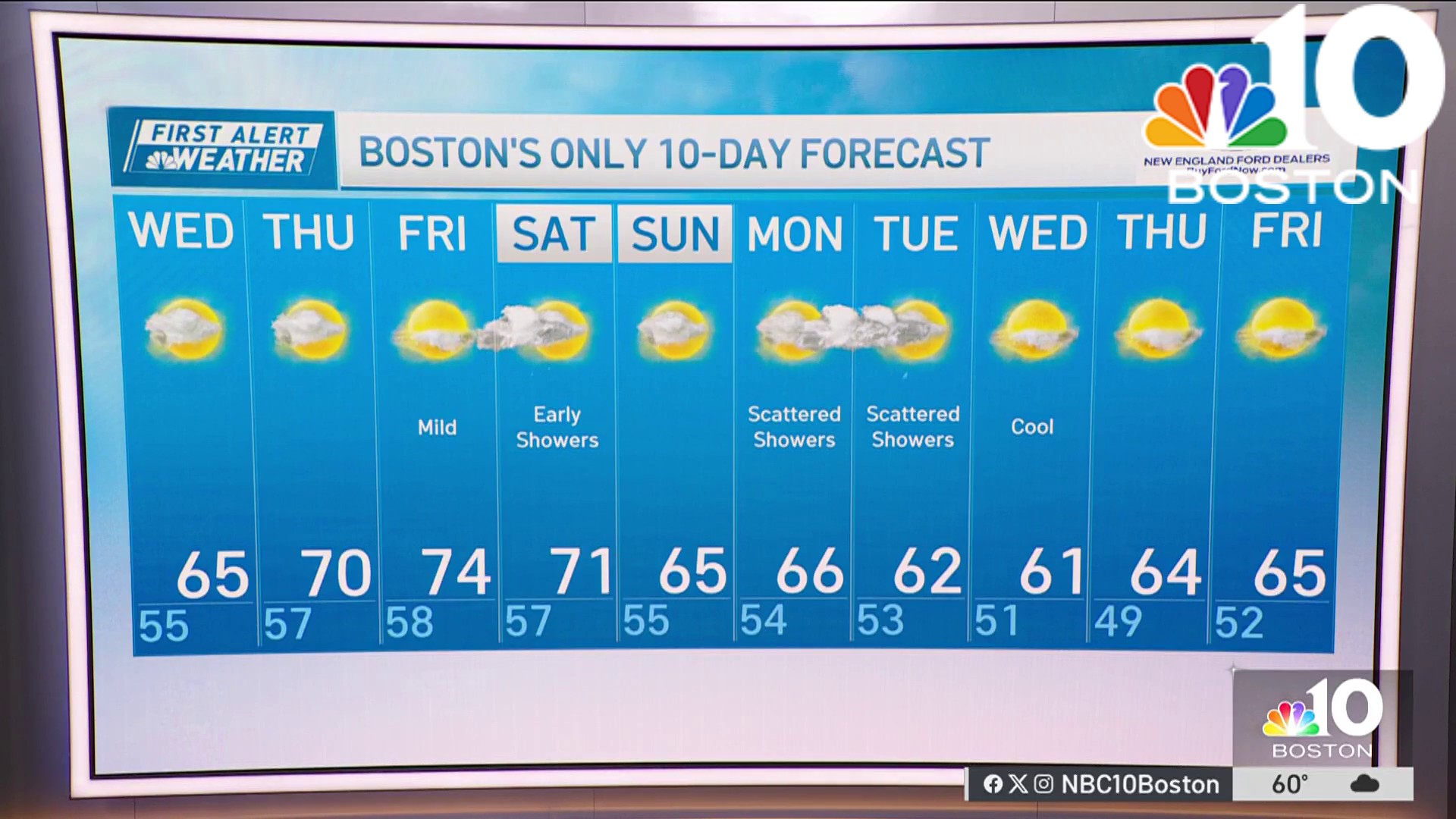
After we shake off the rain on Monday, the forecast brightens and remains seasonable. We’ll hold onto the sun deep into next week – and right now the weekend looks pretty good. When can we start talking about that?
Stay dry and make the best of the weekend.