
Noticeably colder air has arrived to the region – air that as of mid-morning was 45 degrees colder than this time Monday in northern Maine.
High temperatures will struggle to get out of the 20s to low 30s from north to south and with an occasional northeast breeze 5 to 15 miles per hour, wind chill values will be stuck in the teens and 20s at the warmest time of the day.
STAY IN THE KNOW
Watch NBC10 Boston news for free, 24/7, wherever you are. |
|
Get Boston local news, weather forecasts, lifestyle and entertainment stories to your inbox. Sign up for NBC Boston’s newsletters. |
There won't be much sun either. Some breaks in the cloud cover may develop in far eastern New England as ocean-effect snow showers weaken and leave a leftover flurry here and there Tuesday afternoon.

Get top local stories in Boston delivered to you every morning. Sign up for NBC Boston's News Headlines newsletter.
There won't be more than a dusting here or there but watch for a few isolated slick spots to develop.
Tuesday night, a disturbance will pass well to our southwest, though clouds on the northern fringe of that same system will move through and may produce a passing flurry. Otherwise, the main weather headline will be a moderation in temperature over the coming days. We'll be well into the 30s Wednesday, and low 40s Thursday and around 40 Friday.

A fast-moving are of low pressure will cross the northeast late Thursday and push offshore by Friday morning.
There will be some pockets of North Country snow (accumulating as much as a few inches by Friday morning in northern Vermont to northern Maine) and a mix of rain/snow showers in central and southern areas that will accompany this system as it pushes through.

Behind it, a shot of colder air will move in for the weekend, with below average temperatures, in the low 30s both Saturday and Sunday despite sunny skies.
Weather

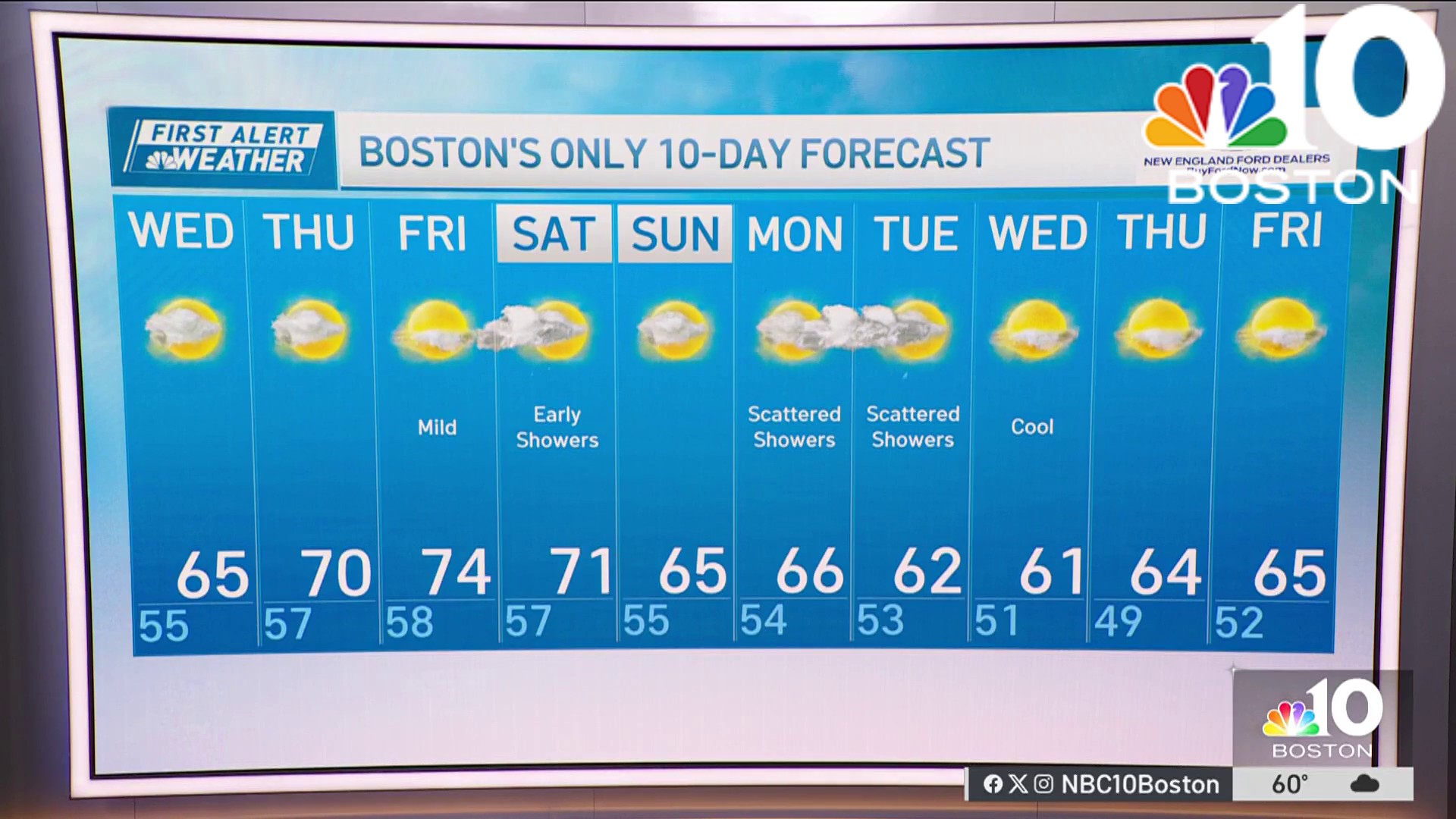
Next week looks quiet with no big storms and a gradual warm up with highs back near 40 by midweek as seen in our exclusive 10-day forecast.