Flash flood warnings and severe thunderstorm warnings were in effect in Maine and Vermont Monday afternoon and evening, but have since expired.
Click here to see more severe weather alerts.
WATCH ANYTIME FOR FREE
Stream NBC10 Boston news for free, 24/7, wherever you are. |
It’s not saying much given the way this summer has gone, but this week certainly should end up the hottest of the season thus far with a potential heat wave and likely heat index values – “feels like temperatures,” or impact on the body – either side of 100 degrees by Thursday and Friday.

Get updates on what's happening in Boston to your inbox. Sign up for our News Headlines newsletter.
In the meantime, a comfortable start Monday will only slowly give way to increasing humidity in southern New England over the course of the day and this increasing moisture will first result in wispy clouds, then in increasing haze and puffy, cumulus clouds during the afternoon.
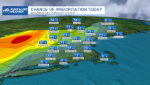
Near and north of the Massachusetts Turnpike, an isolated afternoon shower is a possibility, but from late afternoon onward, some scattered thunderstorms are possible, with the chance increasing from about 30 percent near the Pike to 70 percent and greater in the Berkshires, Vermont, central and northern New Hampshire to western Maine.
With an influx of humidity, these storms may result in isolated flash flooding in those spots that already have seen flooding over the last few weeks, and a few storms may produce locally damaging wind gusts. Above all, remember “when thunder roars, go indoors,” as lightning is a threat in any thunderstorm. On the water, seas of only 1-2 feet with water temperatures in the 75-to-80-degree range at the South Coast and near 70 degrees at eastern beaches make for a great day with a very high UV index.
Monday night will be a bit sticky with patchy fog in southeast New England, then Tuesday brings even more humidity — this means an earlier start to scattered storms during the afternoon into evening as temperatures continue climbing and a few communities may near 90 degrees in the Pioneer Valley, southern New Hampshire and the Massachusetts/New Hampshire border region and western Maine. This will be a sure sign the air is changing and New England is breaking into the big heat we’ve heard so much about in recent weeks across the rest of the nation, and by Wednesday, our First Alert Team is predicting 90 degrees in Boston for the start of a heat wave.

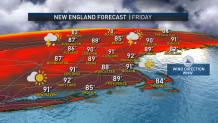
Thursday and Friday should rise into the middle 90s for many in New England, with humid air resulting in heat index values either side of 100 degrees, and our team has issued a First Alert for the impact on the body both days, with urban cooling centers likely to be needed, especially given the limited deep heat so far this season. Our chance of storms actually drops a bit Wednesday and probably for most of us Thursday, simply because there isn’t much warm/cool clash to create those storms – the atmosphere is just hot from surface to top.
Local
In-depth news coverage of the Greater Boston Area.
That changes Friday as cooler air starts to move in aloft, so scattered strong later day thunder is possible, then a surface cold front arrives at some point during the day Saturday, prompting more showers and thunderstorms and marking a likely end to the heat and return to our more familiar, seasonable temperature pattern for Sunday into early next week.


