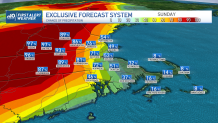
The National Weather Serviced issued thunderstorm flash flood warnings for parts of New England Sunday afternoon.
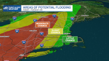
And a flash flood watch was in effect for much of western New England for a heightened risk for localized excessive rainfall.
WATCH ANYTIME FOR FREE
>Stream NBC10 Boston news for free, 24/7, wherever you are. |
Click here for active weather alerts in your area.
Storms will continue to develop, firing up additional rounds of storms and downpours Monday in parts of Connecticut, western Mass., Vermont and New Hampshire. It should all come to an end for southern New England on Tuesday.
Get updates on what's happening in Boston to your inbox. Sign up for our >News Headlines newsletter.

Sunday's downpours began late morning in a very isolated form over Vermont, New Hampshire and Connecticut. Storms continued to strengthen into the evening while pushing north and slightly east into central New Hampshire and Worcester County.
Monday's rain will start early over Connecticut and expand wider across the Berkshires and Green Mountains first, with heavy rain settling into New Hampshire and Eastern Massachusetts by the late morning and into the middle of the afternoon.

Storms and downpours should last most of Monday, slowly departing into the northern country Monday night into early Tuesday. Heavy rain is the primary concern as it may lead to localized street and river flooding.
Weather
Road closures may be expected across parts of the west where more than 2 inches may fall. These storms may produce around 2 inches of rain per hour, but with several rounds of scattered storms Monday, the potential for 3 inches or more will increase across western New England from Connecticut into Vermont and parts of New Hampshire.
Frequent lightning and localized strong wind damage will accompany the strong to severe storms.
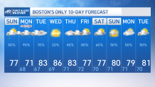
Tuesday should only spin a few showers in but a drier afternoon is expected for the second half of the day across central and southern New England. Wednesday features bright sunny skies with a rise in temperatures to the upper 80s-90s inland. The unsettled weather returns for the second half of next week.


