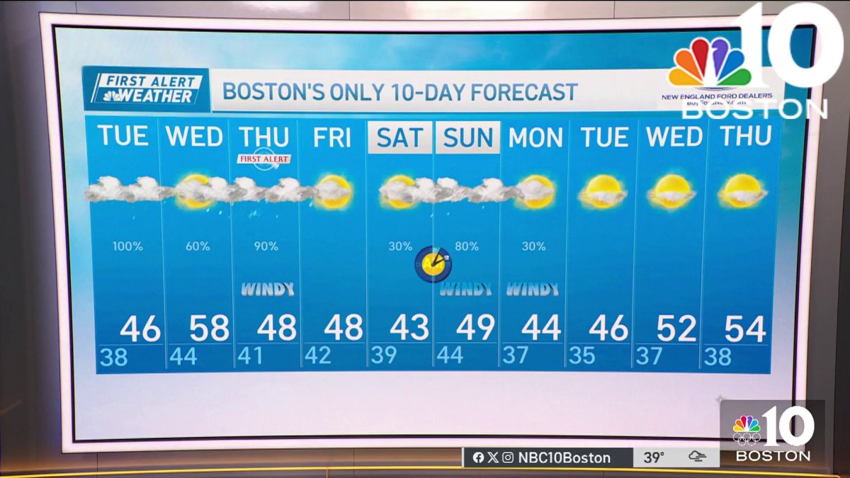
Monday night: Overcast. Lows in the 30s. Tuesday: Showers ramp up to rain. Highs in the 40s. Wednesday: Mostly cloudy and milder, night rain. Highs 55-60.
We continue with an unsettled weather pattern this week as spring-like temperatures are here to stay.
We have an area of high pressure over Canada on this Monday, which means we have an overall dry day in terms of rain showers. Clouds breakup farther inland this afternoon as temperatures reach the 50s in western New England.
WATCH ANYTIME FOR FREE
Stream NBC10 Boston news for free, 24/7, wherever you are. |

The coast and eastern New England will again see a northeast flow, more clouds and even some evening drizzle developing as temps stay in the 40s with a raw feel. Monday night, we continue to see clouds with temps in the 30s for most as some showers return.
Get updates on what's happening in Boston to your inbox. Sign up for our News Headlines newsletter.
A small area of low pressure moves up the east coast for Tuesday and this brings us scattered rain. The rain starts up overnight southwest and spreads northeast through the region by Tuesday morning with the steady showers lingering through the afternoon to evening commute. High temps stay in the 40s.
By Wednesday, our temps warm just a bit to 50s and low 60s as we see a break in rain and some sunshine.
Local
In-depth news coverage of the Greater Boston and New England area.
Wednesday night, we have two systems moving in. One is a weak boundary from the northwest, at the same time, a coastal low moves in from the south. Heavy rain and wind will bring us into Thursday morning and a First Alert day. We may see 1 to 2 iches of rainfall as well as 40 to 50 miles per hour gusts throughout the day as temps cool to the 40s.
Drier are returns for Friday briefly with some sun and highs in the 40s again. Another system moves in for this weekend with rain chances both days and highs in the low 40s. Stay tuned for more on the timing of that rain.

