
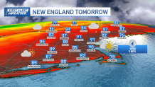
Hot and humid weather remains through Friday, with peak heating this afternoon, reaching heat indices near 100 degrees along the MetroWest areas.
Severe thunderstorm warnings were in effect in parts of Massachusetts, Vermont, New Hampshire and Maine Thursday, but all had expired by early Friday morning.
STAY IN THE KNOW
Watch NBC10 Boston news for free, 24/7, wherever you are. |
|
Get Boston local news, weather forecasts, lifestyle and entertainment stories to your inbox. Sign up for NBC Boston’s newsletters. |
See active weather warnings here.
There may be a few late afternoon/evening showers or thunderstorms in western New England, which may produce strong localized wind gusts. The most prone areas would mainly be in far western Massachusetts and western Connecticut.
Get top local stories in Boston delivered to you every morning. Sign up for NBC Boston's News Headlines newsletter.
Evening convection may continue into the night with some patchy fog. Friday will see similar conditions with slightly lower temperatures, still hot and humid, with the possibility of isolated strong to severe storms in the afternoon. Friday night through Wednesday, the weather will remain humid over the weekend and into Monday, with scattered showers and thunderstorms at times.
Later in the period, humidity levels will decrease, and temperatures will become more seasonable, with the potential for more showers on Wednesday. Temperatures will dip next week with highs in the lower 70s to the upper 60s. The chance of rain pops up almost every day, while not for everyone at the same time, the atmosphere will remain moist and temperatures would likely remain below average all next week.

Meanwhile in the tropics, Lee is coming together with the eyewall set to become a major hurricane, Lee is expected to continue traveling through the southern Atlantic north of Puerto Rico and move north right after. We’ve got a synoptic pattern setup that would keep Lee sitting north of Puerto Rico and then north miles away from the eastern seaboard. A high pressure system off to its northeast would help it steer north, a north-pulling jet stream inland may also support that north movement that would keep it near.


While it may end up out at sea next weekend, our eyes are set in a wide range that extends from Atlantic Canada into our New England coast. With a long-range forecast, much may still change, steering the outcome significantly. Regardless of where it may directly impact the east coast, it would produce huge waves all the way up the east coast.