
We’ve officially made it to the climatological peak of the Atlantic hurricane season, which typically happens each year around Sept. 10.
But up until a few days ago, with the formation of now-Hurricane Francine in the Gulf of Mexico, activity in the tropics had been on an unusual pause -- after forecasters predicted a very busy season.
STAY IN THE KNOW
Watch NBC10 Boston news for free, 24/7, wherever you are. |
|
Get Boston local news, weather forecasts, lifestyle and entertainment stories to your inbox. Sign up for NBC Boston’s newsletters. |
If you recall, Ernesto was the last-named storm to form in the Atlantic basin before Francine, becoming a hurricane on Aug. 14. It weakened and became a remnant area of low pressure on Aug. 20.

Get top local stories in Boston delivered to you every morning. Sign up for NBC Boston's News Headlines newsletter.
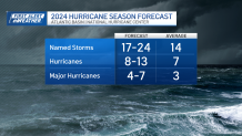
Back in May, the National Oceanic and Atmospheric Administration, or NOAA, predicted an above-normal Atlantic hurricane season, with 17-25 named storms, 8-14 hurricanes and 4-7 major storms. (The numbers were adjusted in an August update, with 17-24 named storms, 8-13 hurricanes and 4-7 major hurricanes.)

Even researchers at Colorado State University predicted a “well above-average Atlantic hurricane season” back in April of this year.
So, why has tropical activity in the Atlantic been so quiet up until now?
Meteorologists and researchers believe it could be several things, but forecasters from Colorado State recently released their thoughts about the lull of activity in the tropics suggesting in a discussion posted in detail on CSU’s website on Sept. 3 few reasons why that might be.
One is that there has been a northward shift in the monsoon trough, which has caused easterly waves coming off the west coast of Africa to emerge too far north over colder ocean waters. Most hurricanes need ocean temperatures around 80 degrees to thrive.
Another reason is stable air in our atmosphere due to warm upper-level temperatures. That doesn’t provide the instability that’s needed for storms to form.
Easterly wind shear has made conditions unfavorable for storms to fully develop and mature across the Atlantic. Also, scientists at CSU pinpointed shifts in the global atmospheric patterns that might have contributed to a quiet season.
Now, this was just a summary of some of CSU’s research. If you’d like to take a deeper dive, visit the discussion on the university’s website here.
Researchers admit that it could be a combination of things that have led to lower activity in the tropics, but they do believe that tropical development will pick up over the next few weeks. CSU still predicts 23 named storms, 12 hurricanes and six major hurricanes to develop this season.
And just as a reminder, the Atlantic hurricane season officially ends on Nov. 30.
Stay with your NBC 10 Boston First Alert Weather Team for constant updates this hurricane season.
Sources:
https://www.noaa.gov/news-release/highly-active-hurricane-season-likely-to-continue-in-atlantic
https://tropical.colostate.edu/forecasting.html
https://tropical.colostate.edu/Forecast/2024_0903_seasondiscussion.pdf

