


Overnight Tonight: Few Showers. Warm. Low: 63.
Friday: Morning Clouds. Afternoon Rain. High: 76.
Saturday: Scattered Clouds. Few Sprinkles. High: 75.
Follow NBC10 Boston on…
Instagram: instagram.com/nbc10boston
TikTok: tiktok.com/@nbc10boston
Facebook: facebook.com/NBC10Boston
X: twitter.com/NBC10Boston
We have a chance for isolated strong to severe storms flashing across the western parts of Massachusetts, Connecticut and Vermont Thursday afternoon and evening, bringing the threat of damaging wind and hail.
A severe thunderstorm warning has been issued for northwestern Vermont through 8:45 p.m.
STAY IN THE KNOW
Watch NBC10 Boston news for free, 24/7, wherever you are. |
|
Get Boston local news, weather forecasts, lifestyle and entertainment stories to your inbox. Sign up for NBC Boston’s newsletters. |


Track live radar below and get the latest severe weather warnings for your area here.
Get top local stories in Boston delivered to you every morning. Sign up for NBC Boston's News Headlines newsletter.
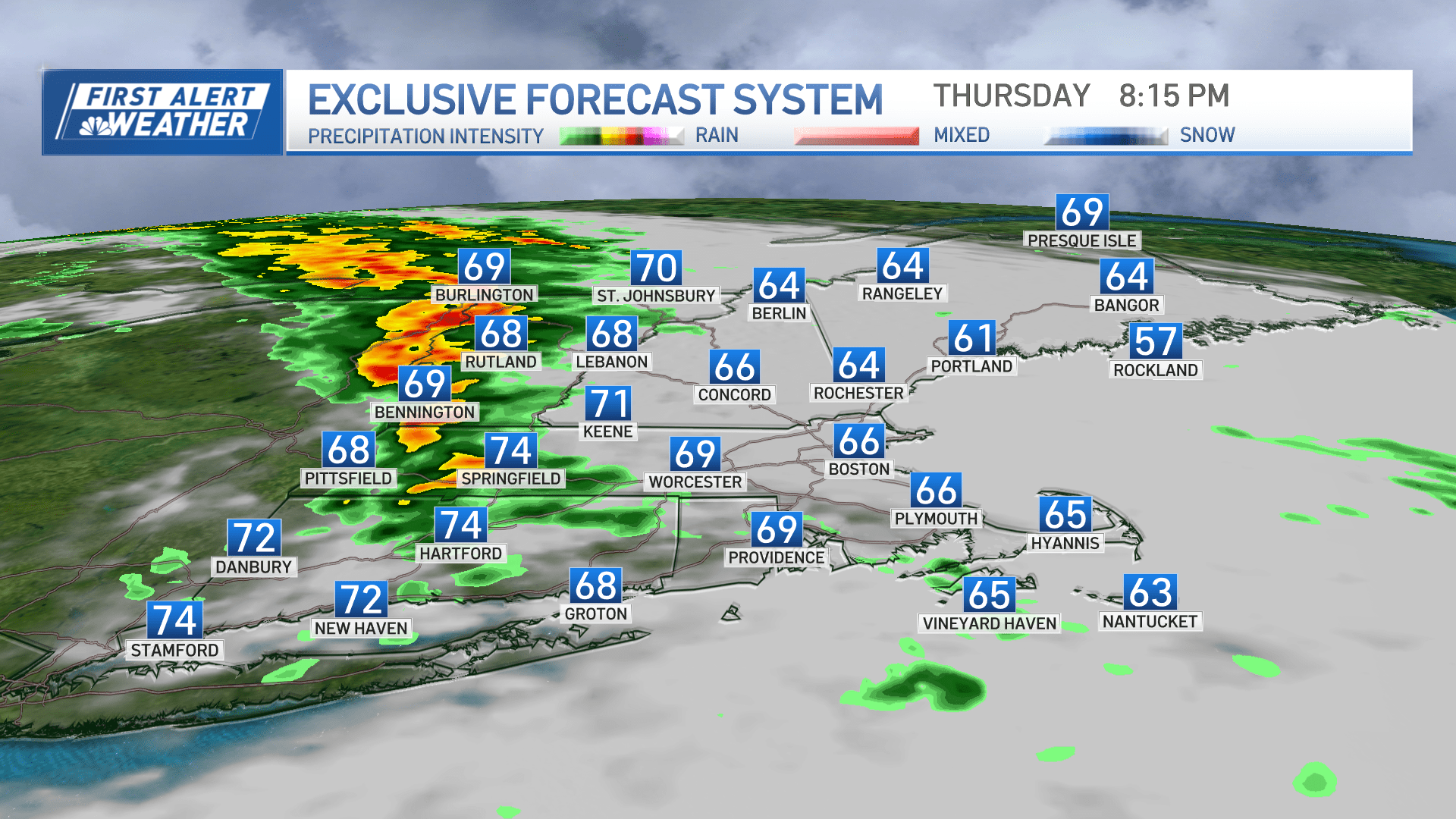
Most of the morning rain remained south and offshore Thursday. Showers continue to linger across southeastern New England through in the early afternoon as a surface low develops around northern Rhode Island.
It will continue to look and feel like it will rain at any minute with warmth and humidity equal to that of the tropics. Dewpoints are sitting near 70 in southern parts of western New England!
This soupy airmass lingers through Thursday night, with slightly lower dewpoints Friday and more comfy air for this weekend.

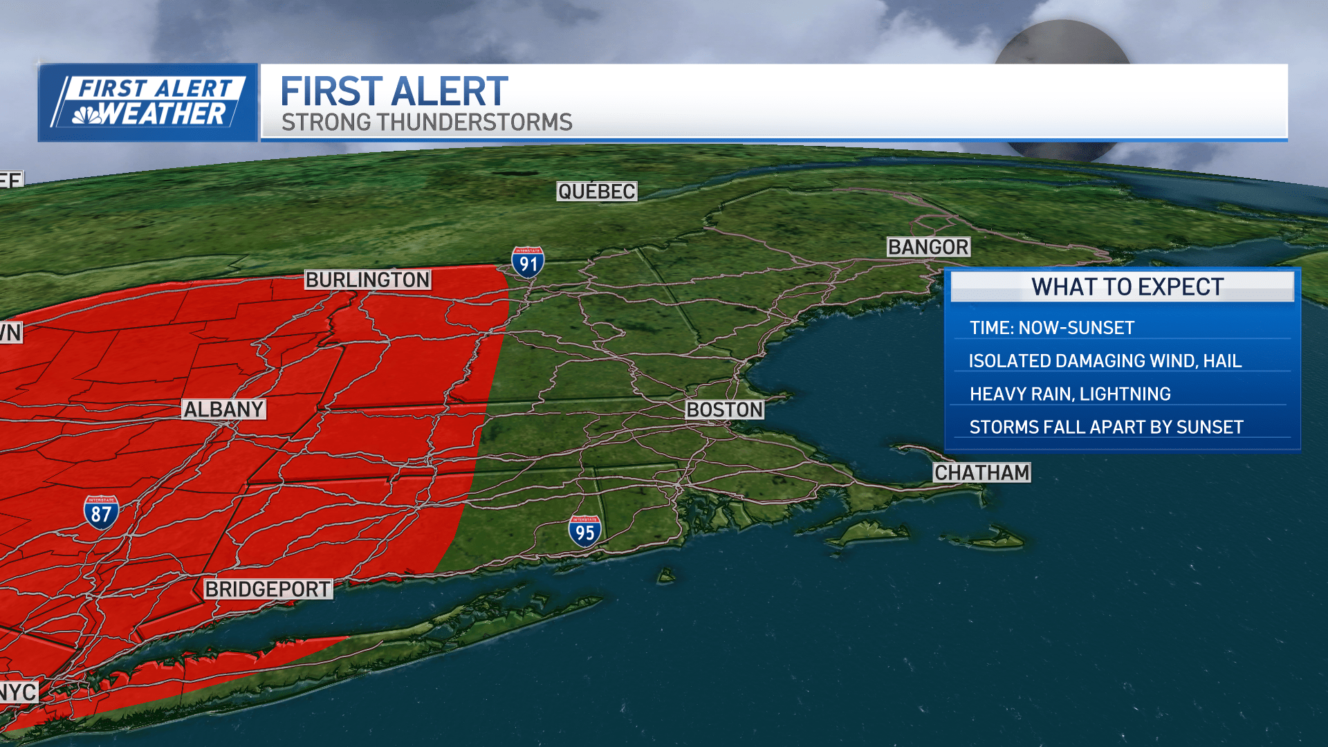
Thunderstorms are still in the forecast for Thursday evening across far western Massachusetts, western Connecticut and western Vermont after 4 p.m. and into the early part of the night. Any storm that rolls through can produce a quick burst of damaging wind, or hail, perhaps prompting the National Weather Service to issue a severe thunderstorm warning.


Remember, heavy rain and lightning are a threat with any storm, regardless of whether or not the storm is warned. If you hear thunder, there is lightning and it’s time to seek immediate shelter.
Weather


As the storms in western New England head east, they turn more northeast at sunset, as the storms move towards Worcester. A few showers roll into Boston late Thursday night, with any lingering storms remaining across the north country around midnight.
Tides are also astronomically high the next few overnights due to the new moon, and pockets of minor coastal flooding will be possible in the typical low-lying areas all along the coast. For the next few nights, tides around midnight or just after are the ones to watch for flooding or splashover.
Friday brings us another warm day with more sun and highs around 80. An upper-level low lingers across the Great Lakes through early next week, so little shortwaves will keep rain chances around for a while. Most of the days will be dry and nights too. Isolated storms or showers will pop in the heat of the afternoon on Friday.
Our chance is lower for Saturday with isolated storms in the north country. Sunday more widespread showers and storms move through, but again in the afternoon to evening. Highs both days this weekend will be in the 70s.
