Friday: Sunshine with a cold wind. Highs in the 30s, wind chill 20s.
Overnight Friday night: Wispy clouds, quieter wind. Lows 20-25.
Saturday: Cloudy with patchy evening snow becoming steady at night. Highs in the 30s.
Sunday: AM snow and coastal mix to lighter PM snow. Highs in the 30s.
The weekend draws near, and our winter storm is on track, heading for us from the Deep South.
But not Friday.
Stream NBC10 Boston news for free, 24/7, wherever you are.
Instead, we'll sit in the cold — and quiet – through Saturday. Highs will manage the mid and upper 30s and winds will be light.

Get updates on what's happening in Boston to your inbox with our News Headlines newsletter.
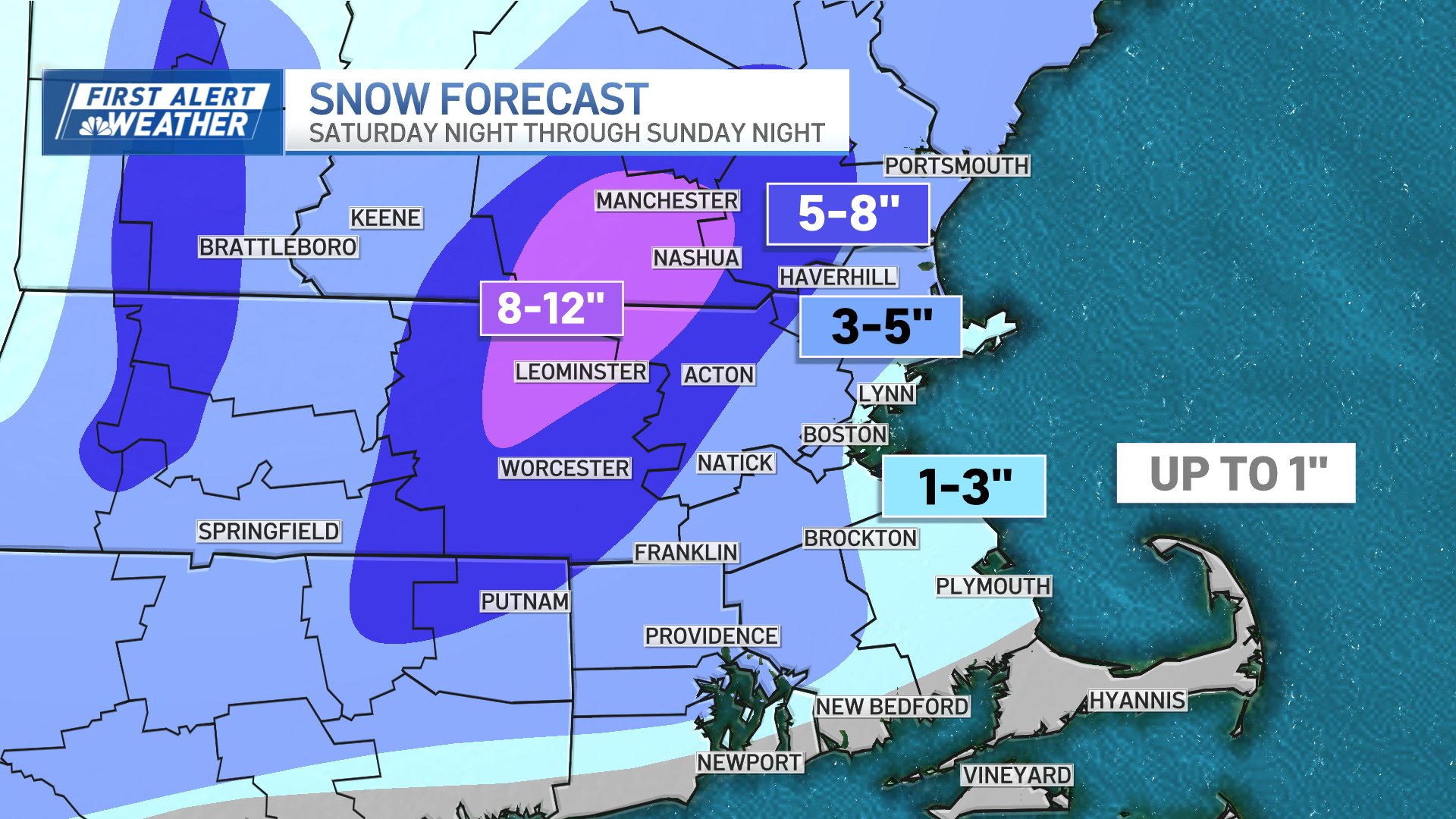
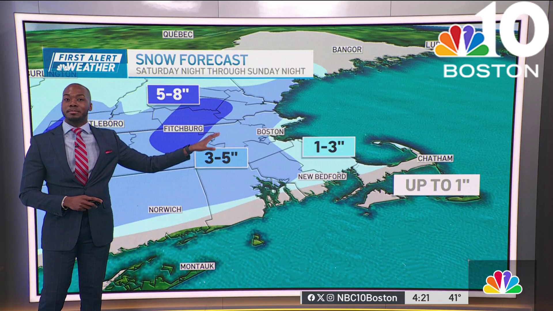
Snow totals this weekend
The event gets underway on Saturday night without much fanfare. There's some wet snow in spots, and there's some mixed rain and snow in others — all rain will fall on Cape Cod and the Islands until the tail end of the storm.
Accumulations into Sunday morning will be light — predominately in the Worcester Hills and southern New Hampshire. As we work through late Sunday morning and into the afternoon, the cold will rush out of the north as the storm begins to deepen offshore.


Snow forecast for Massachusetts
This will accomplish two things: intensify the snow and cause a solid changeover to white as it moves toward the coast. It's in this time frame that things start to stick and the road conditions go downhill.
Throughout the afternoon, the snow will fly at varying intensities as the switchover moves to the Cape Cod Canal. We'll get the lion's share of the accumulation you see on the snowfall map at this time, and it's possible that snowfall rates may approach an inch per hour along Interstate 128 and I-495 (and possibly Route 3 late day).
Strong winds could cause power outages
Winds will also increase along the coast, especially on the Cape and the Islands. Some gusts may top 50 on the Cape, with 40 to 45 miles per hour common elsewhere from Rockport to S. Plymouth.

The storm winds down Sunday night — slowly. Flakes could be flying until midnight with negligible accumulations after 8 p.m. We're cold for cleanup late Sunday.

Numbing air will fall over the Commonwealth as temperatures fall to the upper 10s and low 20s with wind chills in the single digits and low 10s by morning Monday.
We'll catch our breath on Monday, then gear up for a soaking (possibly flooding) rain Wednesday with very strong winds and mild temperatures in the 50s.

'Kitchen sink' storm coming next week
If that's not enough, another storm will threaten by the end of next week. Precipitation to be determined.
You'll be able to track the storm with our interactive radar on the NBC10 Boston app all weekend. Be safe and have a great weekend!