
Monday: Clouds and sun, fresh breeze. Highs near 50.
Overnight Monday night: Partly cloudy. Lows around 30.
Tuesday: Sun and building clouds, chance sprinkle. Highs in the 40s.
Wednesday: Bit breezy, chance sprinkle, night rain/snow showers. Highs 45-50.
Spring begins this week, bringing with it a noticeable dip in temperatures, compared to last week's warmth.
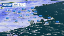
Monday stands out as the warmest day, with highs in the 50s. Gusty winds begin Monday, ranging from 20 to 30 miles per hour making it feel cooler. Tuesday marks the vernal equinox also known as the official start of spring.
Stream NBC10 Boston news for free, 24/7, wherever you are.
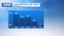
While it may not feel as spring-like as the weekend, temperatures will be typical for this time of year, with highs in the mid-40s following morning lows in the low to mid-30s.
Get updates on what's happening in Boston to your inbox with our News Headlines newsletter.
Wednesday, isolated showers possible, with a chance of a stray flurry early Thursday morning. Highs Wednesday through Friday will remain in the low to mid-40s, while lows steadily drop, reaching the mid-20s by Friday.
Looking ahead to Friday and the weekend, there's potential for another storm system, although timing and confidence levels are currently uncertain.

We will keep you posted with updates as it comes closer.