
Spring temperatures return this weekend. Watch the video to see what else to expect.
Our weekend warmup sneaks in Friday for some spots.
An onshore breeze will keep our temps cooler at the coast with upper 40s, while inland we see 50s to near 60 with sunshine.
WATCH ANYTIME FOR FREE
Stream NBC10 Boston news for free, 24/7, wherever you are. |
As warmer air continues to move in, Friday night’s lows stay in the 30s in southern New England with developing fog.
Morning fog to increasing clouds on Saturday won’t be an issue as we still jump to around 60 on a gusty south wind. The wind ramps up a bit for Sunday with highs in the mid to upper 60s!
Get updates on what's happening in Boston to your inbox. Sign up for our News Headlines newsletter.

Aside from the wind, the St. Patrick’s Day parades are mostly dry (despite possible early spot showers), partly cloudy and warm. Rain approaches Sunday night.


More on South Boston's St. Patrick's Day parade


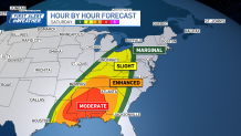
A large low pressure system will be trudging across the country this week. Each day, severe weather will develop and cause major damage in spots.
A moderate risk of tornadoes, damaging wind, & hail covers mush of the Midwest Friday night, while the threat pivots south across the Gulf Coast Saturday.
The severe storm risk then pivots to the east coast for Sunday night into Monday morning. Though the damaging wind, hail and tornado threat remains to the south of New England, there will be some thunderstorms around Connecticut and Rhode Island to Massachusetts' South Coast Sunday night into Monday morning.
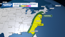
Isolated severe thunderstorms with damaging wind or hail will cross Connecticut to western Massachusetts overnight Sunday. The gusty wind will be from the south after sunset on Sunday, between 40 and 45 mph. Around 1-2” of rain will also fall as a squall line forms Sunday morning.

That is when we have a First Alert for the worst of the rain, wind and a few thunderstorms
We stay breezy with a west wind and temps in the 50s for the rest of Monday.
Even though a cold front moves through Monday, on Tuesday we still reach the 50s. More 50s and 60s are on the horizon next week as we welcome astronomical spring on Thursday.