
As New England residents sip on their pumpkin spice lattes and enjoy the vibrant foliage, the region's weather is poised to take another turn.
Wednesday, we’ll keep tracking steady clouds with a few spot showers expected south of the Massachusetts Turnpike, with highs in the low to mid-60s. Wednesday night, weak ridging and subsidence behind the departing trough will lead to dry weather with partial clearing. However, another passing shortwave overnight may keep some clouds around, impacting radiational cooling. Lows are expected to be mostly in the 40s, with the possibility of patchy fog.
WATCH ANYTIME FOR FREE
>Stream NBC10 Boston news for free, 24/7, wherever you are. |
Thursday will bring pleasant weather as upper-level ridging moves into New England, allowing for warming temperatures aloft. High pressure builds east of the region, setting up a southwest flow of milder air into southern New England. Expect mostly sunny skies with high temperatures reaching the mid to upper 60s. A perfect day to enjoy the fall weather.
Get updates on what's happening in Boston to your inbox. Sign up for our >News Headlines newsletter.
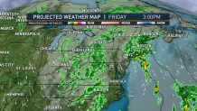
By Friday, though, our ridge departs and we’ll see incoming rain lasting us through early Sunday (depends on where across New England you’ll be at). A deep trough moving through the Mid Atlantic will bring significant moisture to the region, potentially leading to heavy rain, especially on Saturday. The dynamic nature of the system as a low out of the west merges in may cause the moisture to linger into Sunday.
Gusty winds are expected on Sunday into Monday, with gusts as high as 30 to 40 knots over the Cape and Islands and 25 to 35 knots inland. The exact wind speeds will depend on the system's track and timing. Behind the exiting low, New England will enjoy mid-level ridging and building high pressure, leading to subsidence and dry weather. However, this will also bring cooler northwest winds, possibly resulting in frost Monday night into Tuesday.