
That’s right, we’re looking at snow to the north and west of Boston on Friday. Here’s what to expect where you live.
Follow NBC10 Boston:
https://instagram.com/nbc10boston
https://tiktok.com/@nbc10boston
https://facebook.com/NBC10Boston
https://twitter.com/NBC10Boston
https://bsky.app/profile/nbcboston.com
We’re moving the needle in a warmer direction Wednesday and Thursday.
While we’re not realizing the true potential of this airmass, we will manage to sneak into the 60s away from the coast. Sea breezes at the water’s edge will keep us in the 50s as we enjoy full sunshine Wednesday.
WATCH ANYTIME FOR FREE
Stream NBC10 Boston news for free, 24/7, wherever you are. |
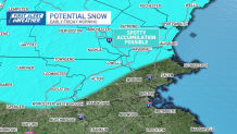
There are more springlike “tricks” ahead, however. A storm rolling out of the Rockies will speed eastward and land in our laps by Friday morning.

Get updates on what's happening in Boston to your inbox. Sign up for our News Headlines newsletter.
As it intensifies by midday Friday, it will drag in colder air from northern New England. There may be enough cold to switch some parts of the Commonwealth and southern New Hampshire over to snow – with minor accumulations.
As the storm pulls away and some sun pokes out in the afternoon, temperatures will bounce back to the 40s as winds increase. We’ll be watching this storm closely.
Saturday pops back into the upper 50s before the cold comes rushing back to finish off the weekend.
Weather Stories


Overall, the pattern stays busy into next week, with another potential storm by Monday. Pollen stays within tolerable limits, but it’s clearly apparent in our forecasts, and only going up from here.